L’Aquila, Italy
Data Map
The Data Map displays earthquake damage and impact observations from EERI field teams and other contributors using EERI’s Photo Upload Tool. Whenever possible, the data map overlays other important layers, including USGS ShakeMaps, PGV/PGA, ground motion stations, and other location data. The Data Map layers are interactive and can be filtered for specific details.
Reconnaissance Photo Gallery

The Reconnaissance Photo Gallery is a repository of photos taken by EERI field teams and other contributors. Many photos are geolocated and allow field teams, researchers, and those involved in recovery effort to identify specific damage locations by site and proximity to other features using the Data Map. The Photo Gallery can be filtered by user and searched for specific records, or used to upload photos in the the field.
Featured Resources
Resources
| Date | Category | Title | Description | |
|---|---|---|---|---|
| 08-21-2018 | Link to external resourceSeismology | USGS Event Page | Earthquake information from USGS including ShakeMap and PAGER | |
| 02-23-2018 | Geotechnical EngineeringReportSeismology | Preliminary Report on the Seismological and Geotechnical Aspects of the April 6 2009 L’Aquila Earthquake in Central Italy | By Jonathan P. Stewart, Giuseppe Di Capua, Robert E. Kayen, D. Scott Kieffer, Edward Button, Giovanna Biscontin, Giuseppe Scasserra and Giuseppe Lanzo, Paolo Tommasi and Alessandro Pagliaroli, Francesco Silvestri and Anna d'Onofrio, Crescenzo Violante, Armando Lucio Simonelli, Rodolfo Puglia, George Mylonakis... | |
| 08-20-2018 | BuildingsLink to external resourceStructural Engineering | Recent Italian Earthquakes: Examination of Structural Vulnerability, Damage, and Post-Earthquake Practices | By Joe Maffei, Paolo Bazzurro, Joshua Marrow, and Agostino Goretti. July 2004, Earthquake Engineering Research Institute. Italy has comprehensive systems in place for the collection of earthquake damage data and the prediction of building vulnerability. Published in 2006, this 180-page report capitaliz... | |
| 08-20-2018 | BuildingsEmergency ManagementSocial impacts | 2002 Molise, Italy, Earthquake Reconnaissance Report | By Paolo Bazzurro and Joe Maffei. July 2004, Earthquake Engineering Research Institute. On October 31 and November 1, 2002, two magnitude Mw 5.7 earthquakes struck the rural Molise region in southeastern Italy, killing 30 people, 27 of whom were children trapped in the collapse of an elementary school. This... | |
| 02-23-2018 | EERI team update | Teams in the field | April 2009, Earthquake Engineering Research Institute. International Teams that EERI is aware of in the field as of week of April 20th. | |
| 02-23-2018 | BuildingsReportSocial impacts | Latest Quick Response Report Gives a Glimpse of L’Aquila Vulnerability | By Abbie B. Liel, Kathryn P. Lynch. October 2009, Natural Hazards Center. The report, by University of Colorado (CU) Department of Civil, Environmental, and Architectural Engineering researchers Abbie Liel and Kathryn Lynch, is the result of a field study following the April 6 L’Aquila, Italy, earthquake. T... | |
| 02-23-2018 | BuildingsReportSeismology | EEFIT UK Team Draft Report Ready + Virtual Disaster Viewer | By Tiziana Rossetto, Navin Peiris, John Alarcon, Emily So, Susanne Sargeant, Victoria Sword-Daniels, Craig Libberton, Enrica Verrucci, Domenico Del Re, Matthew Free. April 2009, Earthquake Engineering Field Investigation Team. The UK Earthquake Engineering Field Investigation Team (EEFIT) has prepared a rep... | |
| 02-23-2018 | EERI team updateHeritage and historic structures | Anecdotes | April 2009, Earthquake Engineering Research Institute & Pacific Earthquake Engineering Research Center. In the past week of working in the field in L’Aquila and the surrounding areas, the EERI/PEER team has met amazing people with incredible stories of survival. We present the following two in this segme... | |
| 02-23-2018 | Ground motionsSeismology | Main Shock Time Histories from station AQV (provided by M.Celebi, USGS) | By M. Celebi. April 2009, United States Geological Survey. Largest peak accelerations of the main shock from station AQV and their amplitude spectra. | |
| 02-23-2018 | DataLink to external resource | Google map showing affected areas | Google map showing affected areas. News and information georeferenced from various sources. |
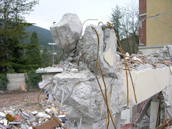
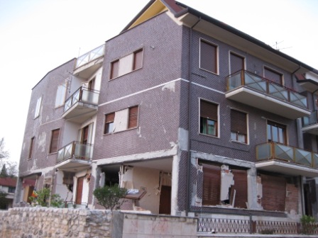
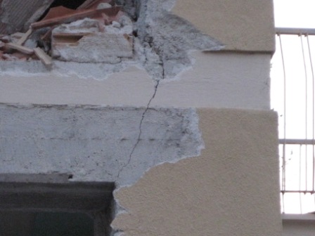
Photo Gallery
Photos in this gallery have been contributed by EERI members and California Earthquake Clearinghouse participants. Photos from this gallery can be used for non-commercial purposes with proper attribution.


| Attachment ID | |
|---|---|
| Caption/Description | |
| Latitude | |
| Longitude | |
| Date Taken | |
| Data Copyright Holder | |
| Photographer | |
| Original Filename | |
| Filename | |
| File Type |
| Record ID | |
|---|---|
| Observer Name | |
| Observer Email | |
| Experience Level of Observer | |
| Observation Category | |
| Description | |
| Building Address | |
| Building Occupancy | |
| Building Type | |
| Structural Damage Level | |
| Overall Damage Level | |
| Foundation Damage Level | |
| Damaged Nonstructural Elements | |
| Date and Time of Observation | |
| Type of Bridge | |
| Lifeline Type | |
| Landslide Type | |
| Type of Operation | |
| Liquefaction Features | |
| Surface Rupture Type | |
| Severity of Tsunami/Seiche | |
| Site Type | |
| Building Name | |
| Building Owner | |
| Decade Built | |
| Foundation | |
| Number of Stories Above Ground | |
| Number of Stories Below Ground | |
| Total Building Floor Area | |
| Retrofitted | |
| Year of Retrofit | |
| Vertical Load System | |
| Lateral Load System | |
| Energy Dissipation Devices | |
| Observation Type | |
| Cause of Structural Damage | |
| Damaged Structural Elements | |
| Nonstructural Damaged Level | |
| Safety Assessment Placard | |
| Site Observation | |
| Estimated Economical Loss (Lifelines & Transportation) | |
| Additional Notes (Building) | |
| Affiliation | |
| Observer Area of Expertise | |
| Professional Licenses Held By Observer | |
| Timezone | |
| Site Owner | |
| Site Latitude | |
| Site Longitude | |
| Functionality | |
| Estimated Repair Time | |
| Deaths | |
| Injuries | |
| Seismic Strengthening Features | |
| Causes of Lifeline Damage | |
| Estimated Repair Time | |
| Estimated Economic Loss | |
| Additional Notes (Lifelines & Transportation) | |
| Bridge ID | |
| Route | |
| Bridge Foundation | |
| Length (ft) | |
| Width (ft) | |
| Year Built | |
| Retrofit | |
| Year of Retrofit | |
| Causes of Damage (Bridges) | |
| Bridge Functional | |
| Estimated Repair Time | |
| Additional Notes (Bridges) | |
| Lead Organization | |
| Level of Lead Organization | |
| Type of Organization | |
| Incident Command System Functional Area | |
| Additional notes (Emergency Management/Response) | |
| Surface Area Affected (sq. m.) | |
| Ejecta Material | |
| Horizontal Displacement (m) | |
| Vertical Displacement (m) | |
| Additional Notes (Liquefaction/Lateral Spreading) | |
| Material Type | |
| Area Affected (square meters) | |
| Vulnerable Facilities | |
| Additional Notes (Ground Deformation - Landslide) | |
| Offset Feature Type | |
| Slip Length (meters) | |
| Fault Movement | |
| Slip Azimuth (degrees) | |
| Plunge (degrees) | |
| Additional Notes (Ground Deformation - Fault Rupture) | |
| Body of Water | |
| Wave 1 Time of Arrival (Local Time) | |
| Wave 1 Height (Meters) | |
| Wave 2 Time of Arrival (Local Time) | |
| Wave 2 Height (Meters) | |
| Wave 3 Time of Arrival (Local Time) | |
| Wave 3 Height (Meters) | |
| Were Tsunami Warnings Issued at This Location | |
| Additional Notes (Tsunami/Seiche) | |
| Causes of Damage (Other) | |
| Estimated Economic Loss (Other) | |
| Additional Notes (Other) |
Data Map
A preview of the data map is shown below. For more functionality (toggle layers, adjust transparency, and view data tables), view the map on ArcGIS Online here.
Materials on this site and on the data maps may be used with proper atrribution (Name of individual or organizational contributor) for non-commercial uses. Questions, contact eeri@eeri.org
How to Contribute
EERI members and other earthquake risk reduction professionals can contribute to reconnaissance efforts for this earthquake in the following ways:
1. Share your reconnaissance plans
If you will be participating as a part of a reconnaissance mission, recovery mission, or traveling to the impacted area for any other purpose, please share information about your plans through the Contact Form. EERI can help link you to others in the field, support you in efforts to share photos or observations, and connect you with the EERI team (if one is mobilized).
2. Check into the local clearinghouse
If you plan to conduct reconnaissance, please make sure to be in communication with Recep “Ray” Cakir, who is leading the Physical Clearinghouse in Ankara. The information collected through reconnaissance can provide valuable situational awareness for those responding. The physical clearinghouse will close on May 15, 2023 and, at that time, local clearinghouse operations will continue virtually. Ray will continue to serve as the Clearinghouse contact and can be reached at:
- Email: cakir.recep@gmail.com
- What’sApp: +1-360-628-3550
3. Contribute Photos and Notes
Contribute post-earthquake field observations and photos. Once reconnaissance teams and others begin to share their photos and observations, they will also be shown on the virtual clearinghouse Data Map and Photo Gallery pages. All submissions will help inform both reconnaissance and recovery efforts. A video tutorial on how to upload photos is available here.
For login information and help, please email maggie@eeri.org.
4. Submit an Paper to the Earthquake Spectra Special Collection
Earthquake Spectra invites earthquake researchers to contribute papers to a special collection titled, “Impact of the February 6, 2023 M7.8 and M7.6 Earthquakes in Turkey on the Built Environment, and Implications on Seismic Hazard.” More Information about how to submit a paper is available here: https://www.eeri.org/about-eeri/news/16199-earthquake-spectra-announces-special-collection-of-past-papers-on-turkey-syria-and-call-for-new-papers-on-the-february-2023-earthquake-sequence.
5. Review Ethical Reconnaissance Training Materials
As you consider reconnaissance, you are encouraged to review training materials for ethical reconnaissance from CONVERGE, available here: https://converge.colorado.edu/resources/
Other Ways to Contribute
Earthquake investigators are encouraged to contact EERI staff at eqclearinghouse@eeri.org if they have suggestions about how they can contribute to this clearinghouse effort.
EERI members and other earthquake risk reduction professionals can contribute to reconnaissance efforts for this earthquake in the following ways:
1. Contribute Photos and Notes
There are several ways that you can contribute to our data collection effort. (A) Contribute post-earthquake field observations and photos or (B) contribute relevant pre-event images of the impacted area to provide baseline data for locations that field teams should visit to observe impacts. Once reconnaissance teams and others begin to share their photos and observations, they will also be shown on the virtual clearinghouse Data Map and Photo Gallery pages. All submissions will help inform both reconnaissance and recovery efforts.
Here is a video on how to use our batch uploader tool here.
For login information and help, please email eqclearinghouse@eeri.org.
Earthquake investigators are encouraged to contact EERI Clearinghouse staff at eqclearinghouse@eeri.org if they have suggestions about how they can contribute to this clearinghouse effort.
About
What is A Virtual Clearinghouse?
Virtual Clearinghouses are part of EERI’s Learning for Earthquakes (LFE) program. Beginning in 2009, EERI began to host a series of virtual earthquake clearinghouses after major earthquakes where information coming from the affected area could be quickly shared with members and others. These virtual clearinghouses are websites that contain early information provided by investigators from a variety of disciplines, including members of EERI reconnaissance teams. The virtual clearinghouses primarily capture ephemeral data about each event, but may also be updated with recovery and rebuilding information over time. For a complete list of EERI virtual clearinghouse sites and more information about the Learning From Earthquakes program, visit http://www.learningfromearthquakes.org.
How do I use this site?
EERI members and other investigators are encouraged to use this clearinghouse website to share brief observations and photos from the field as well as link to other resources or websites where more detailed information can be found. Please help contribute to our effort.
The Resources page displays all the resources collected through various sources (i.e. field reconnaissance posts, reconnaissance reports, links to previously collected data sources, housing reports for the affected area, etc.) in a searchable summary table. These resources are organized by categories. This page provides users with several resources including reconnaissance reports. It also contains links to other sites for more information.
The Data Map displays observations (primarily captioned photos but occasionally other data) from EERI field teams or other contributors showing earthquake damage and impacts. Many of these photos are geolocated to allow field teams, researchers and those involved in the recovery effort to identify specific damage locations.
The Photo Gallery is a database of these photos that can be searched for specific information. Data Maps also overlay many data layers from other organizations including the USGS shake maps and ground motion stations when possible.
The How to Contribute page identifies ways that EERI members and other earthquake risk reduction experts can contribute to the reconnaissance effort and virtual clearinghouse site.
If you are interested in a particular topic, use the search bar at the top of the page to find information on specific subjects, navigate posts, and uncover related media articles. Additionally, use the search bar to explore the Photo Gallery to see what has been posted thus far.
How does EERI respond to earthquakes?
What does a reconnaissance team do?
EERI responds to earthquakes as a part of its Learning from Earthquakes (LFE) program. EERI often sends a reconnaissance team of earthquake risk mitigation experts to investigate earthquake impacts depending on the earthquake magnitude, location, extent of impacts on the built environment, funding constraints, and many other factors. The reconnaissance team makes a rapid, general damage survey of the affected area, documents initial important observations from the particular earthquake, and assesses the need for follow-up areas of research. Observations and findings from these teams support emergency response and recovery activities in the short term and improve the understanding of natural hazards and how to mitigate their impacts in the long term.
Who is EERI?
The Earthquake Engineering Research Institute (EERI) is a nonprofit multi-disciplinary technical society of engineers, practicing professionals, and researchers dedicated to reducing earthquake risk. For more information visit www.eeri.org.