Mexico City, Mexico
Data Map
The Data Map displays earthquake damage and impact observations from EERI field teams and other contributors using EERI’s Photo Upload Tool. Whenever possible, the data map overlays other important layers, including USGS ShakeMaps, PGV/PGA, ground motion stations, and other location data. The Data Map layers are interactive and can be filtered for specific details.
Reconnaissance Photo Gallery
The Reconnaissance Photo Gallery is a repository of photos taken by EERI field teams and other contributors. Many photos are geolocated and allow field teams, researchers, and those involved in recovery effort to identify specific damage locations by site and proximity to other features using the Data Map. The Photo Gallery can be filtered by user and searched for specific records, or used to upload photos in the field.
Featured Resources
Resources
| Date | Category | Title | Description | |
|---|---|---|---|---|
| 11-30-2018 | EERI team updateLink to external resource | Mexico Earthquake of September 19, 1985, Earthquake Spectra | Mexico Earthquake of September 19, 1985, Earthquake Spectra | |
| 11-30-2018 | Link to external resourceReportSeismology | Evaluation of the Effects of the 1985 Michoacan Earthquake on the Water Systems in Metropolitan Mexico City | by A. Gustavo Ayala, Michael J. O'Rourke, and J. Alberto Escobar August 1990, Earthquake Engineering Research Institute - Earthquake Spectra During the Michoacan earthquake of September 19, 1985, the water supply and distribution systems of Metropolitan Mexico City were severely damaged. | |
| 11-30-2018 | Link to external resourceReportSeismology | Earthquake Engineering Field Investigation Team (EEFIT) Field Report | by E.D. Booth, MA, MICE, MIStructE J.W. Pappin, BE, ME, PhD, MICE J.H. Mills, BEng, PhD, MICE M.R. Degg, BSc R.S. Steedman, BSc, MPhil, PhD September 1986, EEFIT This report was made possible by generous funding, which EEFIT records with sincere gratitude, from the following: Ove Arup & Partners, Consulti... | |
| 11-29-2018 | EERI team updateReportSeismologyStructural Engineering | Observations on the Earthquake in Mexico City from the May 1987 Newsletter | by Aldolfo Zeevaert Wiechers, and Adolfo E. Zeevaert Wolf May 1987, Earthquake Engineering Research Institute | |
| 11-29-2018 | EERI team updateLink to external resource | The Culprit in Mexico City—Amplification of Motions, Earthquake Spectra publication | by M. Celebi, J. Prince, C. Dietel, M. Onate, and G. Chavez May 1987, Earthquake Engineering Research Institute - Earthquake Spectra | |
| 11-29-2018 | EERI team updateLink to external resourceReport | Performance of Steel Structures in the September 19 and 20, 1985 Mexico Earthquakes | by R. D. Hanson and H. W. Martin May 1987, Earthquake Engineering Research Institute - Earthquake Spectra |
Photo Gallery
Photos in this gallery have been contributed by EERI members and California Earthquake Clearinghouse participants. Photos from this gallery can be used for non-commercial purposes with proper attribution.
| Attachment ID | |
|---|---|
| Caption/Description | |
| Latitude | |
| Longitude | |
| Date Taken | |
| Data Copyright Holder | |
| Photographer | |
| Original Filename | |
| Filename | |
| File Type |
| Record ID | |
|---|---|
| Observer Name | |
| Observer Email | |
| Experience Level of Observer | |
| Observation Category | |
| Description | |
| Building Address | |
| Building Occupancy | |
| Building Type | |
| Structural Damage Level | |
| Overall Damage Level | |
| Foundation Damage Level | |
| Damaged Nonstructural Elements | |
| Date and Time of Observation | |
| Type of Bridge | |
| Lifeline Type | |
| Landslide Type | |
| Type of Operation | |
| Liquefaction Features | |
| Surface Rupture Type | |
| Severity of Tsunami/Seiche | |
| Site Type | |
| Building Name | |
| Building Owner | |
| Decade Built | |
| Foundation | |
| Number of Stories Above Ground | |
| Number of Stories Below Ground | |
| Total Building Floor Area | |
| Retrofitted | |
| Year of Retrofit | |
| Vertical Load System | |
| Lateral Load System | |
| Energy Dissipation Devices | |
| Observation Type | |
| Cause of Structural Damage | |
| Damaged Structural Elements | |
| Nonstructural Damaged Level | |
| Safety Assessment Placard | |
| Site Observation | |
| Estimated Economical Loss (Lifelines & Transportation) | |
| Additional Notes (Building) | |
| Affiliation | |
| Observer Area of Expertise | |
| Professional Licenses Held By Observer | |
| Timezone | |
| Site Owner | |
| Site Latitude | |
| Site Longitude | |
| Functionality | |
| Estimated Repair Time | |
| Deaths | |
| Injuries | |
| Seismic Strengthening Features | |
| Causes of Lifeline Damage | |
| Estimated Repair Time | |
| Estimated Economic Loss | |
| Additional Notes (Lifelines & Transportation) | |
| Bridge ID | |
| Route | |
| Bridge Foundation | |
| Length (ft) | |
| Width (ft) | |
| Year Built | |
| Retrofit | |
| Year of Retrofit | |
| Causes of Damage (Bridges) | |
| Bridge Functional | |
| Estimated Repair Time | |
| Additional Notes (Bridges) | |
| Lead Organization | |
| Level of Lead Organization | |
| Type of Organization | |
| Incident Command System Functional Area | |
| Additional notes (Emergency Management/Response) | |
| Surface Area Affected (sq. m.) | |
| Ejecta Material | |
| Horizontal Displacement (m) | |
| Vertical Displacement (m) | |
| Additional Notes (Liquefaction/Lateral Spreading) | |
| Material Type | |
| Area Affected (square meters) | |
| Vulnerable Facilities | |
| Additional Notes (Ground Deformation - Landslide) | |
| Offset Feature Type | |
| Slip Length (meters) | |
| Fault Movement | |
| Slip Azimuth (degrees) | |
| Plunge (degrees) | |
| Additional Notes (Ground Deformation - Fault Rupture) | |
| Body of Water | |
| Wave 1 Time of Arrival (Local Time) | |
| Wave 1 Height (Meters) | |
| Wave 2 Time of Arrival (Local Time) | |
| Wave 2 Height (Meters) | |
| Wave 3 Time of Arrival (Local Time) | |
| Wave 3 Height (Meters) | |
| Were Tsunami Warnings Issued at This Location | |
| Additional Notes (Tsunami/Seiche) | |
| Causes of Damage (Other) | |
| Estimated Economic Loss (Other) | |
| Additional Notes (Other) |
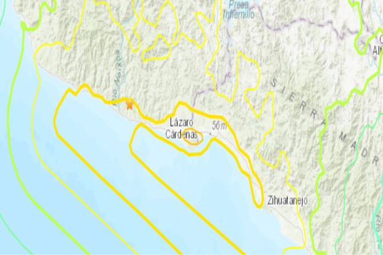
Data Map
A preview of the data map is shown below. For more functionality (toggle layers, adjust transparency, and view data tables), view the map on ArcGIS Online here (link to ArcGIS map).
Materials on this site and on the data maps may be used with proper atrribution (Name of individual or organizational contributor) for non-commercial uses. Questions, contact eeri@eeri.org
How to Contribute
EERI members and other earthquake risk reduction professionals can contribute to reconnaissance efforts for this earthquake in the following ways:
1. Share your reconnaissance plans
If you will be participating as a part of a reconnaissance mission, recovery mission, or traveling to the impacted area for any other purpose, please share information about your plans through the Contact Form. EERI can help link you to others in the field, support you in efforts to share photos or observations, and connect you with the EERI team (if one is mobilized).
2. Check into the local clearinghouse
If you plan to conduct reconnaissance, please make sure to be in communication with Recep “Ray” Cakir, who is leading the Physical Clearinghouse in Ankara. The information collected through reconnaissance can provide valuable situational awareness for those responding. The physical clearinghouse will close on May 15, 2023 and, at that time, local clearinghouse operations will continue virtually. Ray will continue to serve as the Clearinghouse contact and can be reached at:
- Email: cakir.recep@gmail.com
- What’sApp: +1-360-628-3550
3. Contribute Photos and Notes
Contribute post-earthquake field observations and photos. Once reconnaissance teams and others begin to share their photos and observations, they will also be shown on the virtual clearinghouse Data Map and Photo Gallery pages. All submissions will help inform both reconnaissance and recovery efforts. A video tutorial on how to upload photos is available here.
For login information and help, please email maggie@eeri.org.
4. Submit an Paper to the Earthquake Spectra Special Collection
Earthquake Spectra invites earthquake researchers to contribute papers to a special collection titled, “Impact of the February 6, 2023 M7.8 and M7.6 Earthquakes in Turkey on the Built Environment, and Implications on Seismic Hazard.” More Information about how to submit a paper is available here: https://www.eeri.org/about-eeri/news/16199-earthquake-spectra-announces-special-collection-of-past-papers-on-turkey-syria-and-call-for-new-papers-on-the-february-2023-earthquake-sequence.
5. Review Ethical Reconnaissance Training Materials
As you consider reconnaissance, you are encouraged to review training materials for ethical reconnaissance from CONVERGE, available here: https://converge.colorado.edu/resources/
Other Ways to Contribute
Earthquake investigators are encouraged to contact EERI staff at eqclearinghouse@eeri.org if they have suggestions about how they can contribute to this clearinghouse effort.
EERI members and other earthquake risk reduction professionals can contribute to reconnaissance efforts for this earthquake in the following ways:
1. Volunteer with the Virtual Earthquake Reconnaissance Team
Volunteer to be a part of the Virtual Earthquake Reconnaissance Team (VERT). VERT is calling for volunteers for three (3) main tasks:
- Geographically locate (long/lat) any sites that would be of interest to GEER (Geotechnical Extreme Events Reconnaissance).
- Geographically locate (long/lat) buildings that have videos of collapse on social media. EERI has a number of videos already downloaded and they are looking for people interested in finding the location of these buildings.
- Curate the Virtual Clearinghouse on a variety of topics.
If you are interested in any of these topics, please sign up in the following google spreadsheet document. Please write your name and email. If someone has already written their name and email, please coordinate with them to do research on this topic.
<insert Google Sheets link with VERT contact info>
2. Contribute Photos and Notes
There are several ways that you can contribute to our data collection effort. (A) Contribute post-earthquake field observations and photos or (B) contribute relevant pre-event images of the impacted area to provide baseline data for locations that field teams should visit to observe impacts. Once reconnaissance teams and others begin to share their photos and observations, they will also be shown on the virtual clearinghouse Data Map and Photo Gallery pages. All submissions will help inform both reconnaissance and recovery efforts.
Here is a video on how to use our batch uploader tool here.
For login information and help, please email Intern’s first and last name (intern’s email).
3. Use the Fulcrum App
In addition to our Photo Upload Tool, EERI is using the Fulcrum App for gathering information in the field.
- If you already have a Fulcrum account through your organization and would prefer to use EERI’s Fulcrum data collection form (app), please contact Beki McElvain (bmcelvain@eeri.org) to be added to an existing effort as a member.
- If you have a Fulcrum data collection form (app) you would like to invite others to use, please contact Beki McElvain (bmcelvain@eeri.org) at EERI to share your form (app) with our organization.
- If you have data you would like to share with EERI through your own Fulcrum App, EERI may visualize your data on our Data Map on a case-by-case basis. Please contact Beki McElvain (bmcelvain@eeri.org) to request this.
Fulcrum can be downloaded easily for both Android and iOS devices.
4. Inform EERI of your reconnaissance plans
If you will be participating as a part of a reconnaissance mission, recovery mission, or traveling to the impacted area for any other purpose, please contact Maggie Ortiz-Millan (maggie@eeri.org) to inform her of your timeline and travel details. EERI can help link you to others in the field, support you in efforts to share photos or observations, and connect you with the EERI team (if one is mobilized).
5. Team Coordination
EERI is working to facilitate coordination among organizations providing responses to this earthquake event in the following ways:
1) Support colleagues in the field by providing organized and non-redundant communication.
2) Coordinate reconnaissance activities among activated organizations.
3) Determine the value of establishing collaborative actions or joint efforts among teams or organizations.
4) Facilitate the compilation and distribution of reconnaissance data from multiple organizations with the purpose of developing a large and rich data set for the earthquake mitigation community to draw upon.
Other Ways to Contribute
Earthquake investigators are encouraged to contact EERI Clearinghouse staff at eqclearinghouse@eeri.org if they have suggestions about how they can contribute to this clearinghouse effort.
About
What is A Virtual Clearinghouse?
Virtual Clearinghouses are part of EERI’s Learning for Earthquakes (LFE) program. Beginning in 2009, EERI began to host a series of virtual earthquake clearinghouses after major earthquakes where information coming from the affected area could be quickly shared with members and others. These virtual clearinghouses are websites that contain early information provided by investigators from a variety of disciplines, including members of EERI reconnaissance teams. The virtual clearinghouses primarily capture ephemeral data about each event, but may also be updated with recovery and rebuilding information over time. For a complete list of EERI virtual clearinghouse sites and more information about the Learning From Earthquakes program, visit http://www.learningfromearthquakes.org.
How do I use this site?
EERI members and other investigators are encouraged to use this clearinghouse website to share brief observations and photos from the field as well as link to other resources or websites where more detailed information can be found. Please help contribute to our effort.
The Resources page displays all the resources collected through various sources (i.e. field reconnaissance posts, reconnaissance reports, links to previously collected data sources, housing reports for the affected area, etc.) in a searchable summary table. These resources are organized by categories. This page provides users with several resources including reconnaissance reports. It also contains links to other sites for more information.
The Data Map displays observations (primarily captioned photos but occasionally other data) from EERI field teams or other contributors showing earthquake damage and impacts. Many of these photos are geolocated to allow field teams, researchers and those involved in the recovery effort to identify specific damage locations.
The Photo Gallery is a database of these photos that can be searched for specific information. Data Maps also overlay many data layers from other organizations including the USGS shake maps and ground motion stations when possible.
The How to Contribute page identifies ways that EERI members and other earthquake risk reduction experts can contribute to the reconnaissance effort and virtual clearinghouse site.
If you are interested in a particular topic, use the search bar at the top of the page to find information on specific subjects, navigate posts, and uncover related media articles. Additionally, use the search bar to explore the Photo Gallery to see what has been posted thus far.
How does EERI respond to earthquakes?
What does a reconnaissance team do?
EERI responds to earthquakes as a part of its Learning from Earthquakes (LFE) program. EERI often sends a reconnaissance team of earthquake risk mitigation experts to investigate earthquake impacts depending on the earthquake magnitude, location, extent of impacts on the built environment, funding constraints, and many other factors. The reconnaissance team makes a rapid, general damage survey of the affected area, documents initial important observations from the particular earthquake, and assesses the need for follow-up areas of research. Observations and findings from these teams support emergency response and recovery activities in the short term and improve the understanding of natural hazards and how to mitigate their impacts in the long term.
Who is EERI?
The Earthquake Engineering Research Institute (EERI) is a nonprofit multi-disciplinary technical society of engineers, practicing professionals, and researchers dedicated to reducing earthquake risk. For more information visit www.eeri.org.