Overview of Nishihara Area
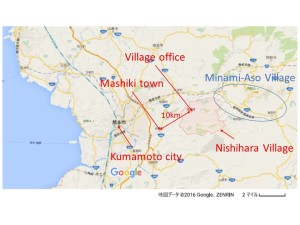
Nishihara area is located 10km northeast from Mashiki town and faces Minami-Aso village on its east end. The area is located on the Futagawa fault zone which showed slips around 2m at the ground surface (right strike-slip fault) [1]. The activity of the Futagawa fault caused severe damage to roads and bridges such as Okirihata Bridge, roads on Okirihata Dam, Tawarayama Tunnel etc. The maps of the area and the fault zones are shown in Figures 1 and 2. The damage information in Minami-Aso Village can be found in other references [2][3].
 |
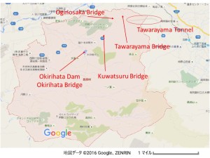 |
| Figure 1. Map of Nishihara area (Source: Google map) | Figure 2. Map of Nishihara Village (Sources: Google map) |
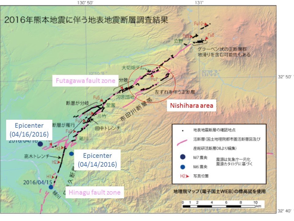 |
| Figure 3. Map of fault zones (Source: JMA [1], translated by the authors) |
Ground motion at Nishihara Area
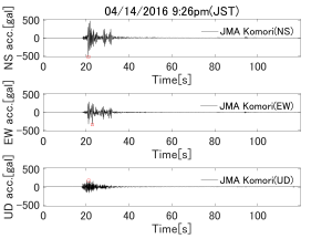
The ground accelerations at Nishihara Village office (Komori) are shown in Figure 4 and 5 The peak ground accelerations during the earthquake on 04/14/2016 were 523.35gal (NS), 341.04gal (EW) and 180.16gal (UD). On 04/16/2016, they were 742.06gal (NS), 770.02gal (EW) and 531.28gal (UD). The peak composite accelerations computed by the square root of the sum of squares were 538.53gal during the earthquake on 04/14 and 866.36gal during the earthquake on 04/16. Comparing to the peak composite acceleration at Mashiki town during the earthquake on 04/14 (1580gal) and 04/16 (1362gal), the peak ground accelerations at Komori were smaller.
 |
 |
| Figure 4. Ground accelerations measured at Komori by Kumamoto prefecture during the foreshock on 04/14/2016 (Raw data source: JMA[5], processed by the authors) | Figure 5. Ground accelerations measured at Komori by Kumamoto prefecture during the mainshock on 04/16/2016 (Raw data source: JMA[5], processed by the authors) |
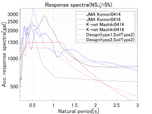
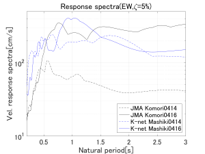
The acceleration and velocity response spectra are shown in Figures 6-9 with the spectra pf ground motions at Mashiki town and the two types of design acceleration response spectra [6]. In the computation of design acceleration spectra, ground type 2 (weak ground) was assumed. From these response spectra, we can observe that the acceleration response spectra at Komori on 04/16 exceed the design spectra and the level of excitation was almost as strong as the excitation at Mashiki town.
 |
 |
|
| Figure 6. Comparison of acceleration response spectra in EW direction (Source: K-net[7], JMA[5] and JARA[6], data processed by the authors) | Figure 7. Comparison of acceleration response spectra in NS direction (Source: K-net[7], JMA[5] and JARA[6], data processed by the authors) | |
 |
 |
|
| Figure 8. Comparison of velocity response spectra in EW direction (Source: K-net[7], JMA[5], data processed by the authors) | Figure 9. Comparison of velocity response spectra in NS direction (Source: K-net[7], JMA[5], data processed by the authors) | |
Overview of damage to roads and tunnels
In this area, severe damage to roads were observed due to the slip of the Futagawa fault (布田川断層) zone. The slip of the fault observed on the ground surface at Okirihata Dam (大切畑ダム) is shown in Figure 10.
 |
| Figure 10. The fault observed on the ground surface at Okirihata Dam (Source: Yoshimi [8]) |
In addition to the damage caused by the fault slip, another type of damage associated with the water leakage from the water drainage system of the dam was observed at Okirihata Dam [9]. After the series of earthquakes, water was drained from the dam to reduce the risk of the collapse. However, the damage to the water drainage system caused water leakage and eventually the leaked water eroded the road next to the dam.
 |
 |
| Figure 11. Damage to road at Okirihata Dam (Source: Kiyota et al. [9]) | Figure 12. Damage to road at Okirihata Dam (Source: Kiyota et al. [9]) |
Severe damage to houses was also observed near Okirihata dam as shown in Figure 13.
 |
| Figure 13. Damage to houses in Okirihata area (Source: Kiyota et al. [9]) |
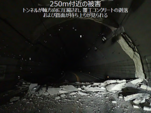
The slip of the Futagawa fault applied high axial compression force to Tawarayama Tunnel (俵山トンネル) as well [9]. Figures 14 and 15 show the damage at Tawarayama Tunnel.
 |
 |
|
| Figure 14. Damage to Tawarayama Tunnel at around 45~50m from the entrance (Source: Kiyota et al. [9]) | Figure 15. Damage to Tawarayama Tunnel at around 250m from the entrance (Source: Kiyota et al. [9]) | |
Overview of damage to bridges
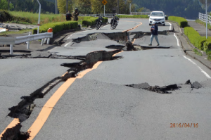
Bridges such as Okirihata Bridge (大切畑大橋), Kuwatsuru Bridge (桑鶴大橋), Oginosaka Bridge (扇の坂橋) and Tawarayama Bridge (俵山大橋) were found to be damaged after the mainshock on 04/16 [4]. At Okirihata Bridge, the girder moved about 1.2m after the mainshock causing failure to bearings. The girder was said to be moved by the strong motion or by the force applied by the large ground deformation caused by the landslide near the bridge [11].
 |
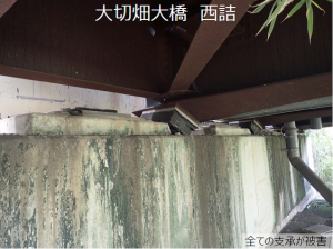 |
| Figure 16. Damage to Okirihata Bridge (Source: Ikeda et al. [10]) | Figure 17. Damage to the bearings at the west end of Okirihata Bridge (Source: Ikeda et al. [10]) |
 |
| Figure 18. Damage to the bearings at the east end of Okirihata Bridge (Source: Ikeda et al. [10]) |
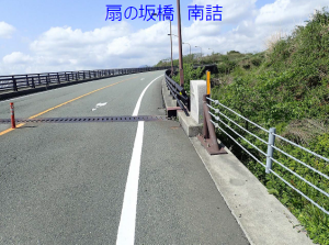
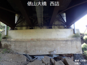
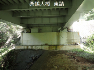
Similar to Okirihata Bridge, the movement of the girders and the damage to the bearing were observed at other bridges such as Kuwatsuru Bridge, Oginosaka Bridge and Tawarayama Bridge. Besides, at Tawarayama Bridge, the damage to the abutment and local buckling of the steel girder were observed as well.
 |
 |
||
| Figure 19. The east end of Kuwatsuru Bridge (Source: Ikeda et al. [10]) | Figure 20. Damage to the bearing at the east end of Kuwatsuru Bridge (Source: Ikeda et al. [10]) | ||
 |
 |
||
| Figure 21. The south end of Oginosaka Bridge (Source: Ikeda et al. [10]) | Figure 22. The east end of Tawarayana Bridge (Source: Ikeda et al. [10]) | ||
 |
 |
||
| Figure 23. Damage to the east end of Tawarayana Bridge (Source: Ikeda et al. [10]) | Figure 24. Damage to the abutment at the west end of Tawarayana Bridge (Source: Ikeda et al. [10]) | ||
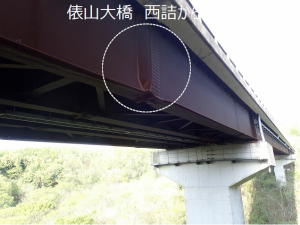 |
| Figure 25. Local buckling of the steel girder of Tawarayana Bridge (Source: Ikeda et al. [10]) |
Though severe damage were found at these bridges, there was an implication that the bridge restrainer worked to prevent the bridges from the collapse. Figure 26 shows the east end of Kuwatsuru Bridge after the mainshock on 04/16. We can see that the girder moved, and the movement was restrained by breaking the right concrete block attached. As a result, the restrainer was broken but the girder did not fall down. We need more investigations to evaluate the effectiveness of these restrainers during the earthquakes [4].
 |
| Figure 26. The east end of Kuwatsuru Bridge (Source: Ikeda et al. [10]) |
References
[1] Japan Meteorological Agency (JMA), “The evaluation of the 2016 Kumamoto earthquake (平成28年(2016年)熊本地震の評価)”, http://www.static.jishin.go.jp/resource/monthly/2016/2016_kumamoto_3.pdf, (retrieved 05/17/2016)
[2] Akiyama M., “Report on damge to bridges (橋梁調査報告(2016年4月15・16日))”, http://committees.jsce.or.jp/eec205/system/files/%E6%A9%8B%E6%A2%81%E8%A2%AB%E5%AE%B3%E8%AA%BF%E6%9F%BB%EF%BC%88%E7%A7%8B%E5%B1%B1%E3%83%BB%E6%97%A9%E5%A4%A7%EF%BC%89_0.pdf, (retrieved: 04/22/2016).
[3] Kong C. and Narazaki Y., “Overview of Damage of Bridges in Aso area”, http://www.eqclearinghouse.org/2016-04-15-kumamoto/2016/04/28/overview-of-the-damage-of-bridges-in-aso-area/, (retrieved 05/17/2016).
[4] Takahashi Y., “The report on the investigation of structures 1 (構造物の調査報告(1))” http://committees.jsce.or.jp/eec2/system/files/%E6%A7%8B%E9%80%A0%E7%89%A9%E8%A2%AB%E5%AE%B3%E5%A0%B1%E5%91%8A%EF%BC%91-2up1d.pdf, (retrieved 04/28/2016).
[5] Japan Meteorological Agency (JMA) website, http://www.data.jma.go.jp/svd/eqev/data/kyoshin/jishin/index.html, (retrieved 05/17/2016).
[6] Japan Road Association (JARA) (2012). “Specifications for Highway Bridges – Seismic design (道路橋示方書 (耐震設計編) 同解説)”, Maruzen Co., Ltd.
[7] National Research Institute for Earth Science and Disaster Prevention (NIED) website, http://www.kyoshin.bosai.go.jp/, (retrieved 04/20/2016).
[8] Yoshimi M., “The overview of faults observed on the ground surface after the 2016 Kumamoto Earthquake (平成28年熊本地震で出現した(地表)地震断層調査概報)”, http://committees.jsce.or.jp/eec2/system/files/%E5%9C%B0%E8%A1%A8%E6%96%AD%E5%B1%A4%EF%BC%9A%E5%90%89%E8%A6%8B%20%E9%9B%85%E8%A1%8C%EF%BC%88%E7%94%A3%E6%A5%AD%E6%8A%80%E8%A1%93%E7%B7%8F%E5%90%88%E7%A0%94%E7%A9%B6%E6%89%80%EF%BC%89%E3%80%80.pdf, (retrieved: 04/22/2016).
[9] Kiyota T., Ikeda T., Uchimura T. and Konagai K., “The investigation of ground failure after the 2016 Kumamoto earthquake ver3.1 (2016年熊本地震地盤被害調査ver3.1)”, http://www.gdm.iis.u-tokyo.ac.jp/KumamotoEQ_Recon_v3-1.pdf, (retrieved: 04/22/2016).
[10] Ikeda T., Kiyota T. and Konagai K., “The report on the damage along the prefecture road route 28 (県道28号線の被害調査速報)”, http://www.gdm.iis.u-tokyo.ac.jp/R28_v01b.pdf, (retrieved: 05/17/2016).
[11] Matsunaga S., Takahashi Y., and Kasai A., “The report on the investigation of structures 1: The damage to Okirihata Bridge (構造物の調査報告(3) 大切畑大橋の被害状況)”, http://committees.jsce.or.jp/eec2/system/files/%E6%A7%8B%E9%80%A0%E7%89%A9%E8%AA%BF%E6%9F%BB%E5%A0%B1%E5%91%8A3%28%E6%9D%BE%E6%B0%B8%29.pdf, (retrieved: 04/22/2016).