Damage investigations that have been conducted after the 2016 Kumamoto earthquake are listed below in chronological order. Key words and points are listed after each investigation to help direct readers to reports of interest.
04/14/2016 9:26pm: The “foreshock”
04/15/2016
04/16/2016 1:25am: The “mainshock”
04/16/2016
04/17/2016
04/18/2016
04/19/2016
04/20/2016
04/21/2016
04/22/2016
Other reports
According to the 17th report by the Ministry of Land, Infrastructure, Transport and Tourism (MLIT) published at 1:00pm (JST) on 04/22/2016 [17], three expressways (Kyushu expressway, Ooita expressway and Kyushu chuo expressway) have been closed due to landslides, road cave-in, road surface uplift and road surface cracking. Furthermore, four national roads (routes 57, 445, 325 and 387) are closed due to landslides and two national roads (routes 210 and 265) are closed due to the danger of rockfall. Five national roads (routes 442, 212, 442, 212 and 445) are closed due to rockfall; national road route 325 is closed due to the bridge failure; and national road route 212 is closed due to anomalies of a pithead.
Other than expressways and national roads, 76 roads have been closed as of 6:00am on 04/22. The main reasons for the closures are rockfall (25 cases), landslides (11 cases), steps of brides (9 cases) and road caves-in (9 cases).
Failures of roads frequently occurred at embankments [9]. Some photos of damage to roads are shown below.
 |
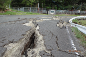 |
| Figure 1. Damage to embankment (Source: Kiyota et al. [9]) | Figure 2. Damage to embankment (Source: Kiyota et al. [9]) |
 |
 |
| Figure 3. Damage to embankment (Source: Kiyota et al. [9]) | Figure 4. Damage to embankment (Source: Kiyota et al. [9]) |
In some places, damage progressed significantly after the mainshock [13]. The photos below are taken at the same place before and after the mainshock on 04/16. In the photo taken after the mainshock, larger cracks across the width of the road can be observed.
 |
 |
| Figure 5. Road before the mainshock (Source: JSCE-West [13]) | Figure 6. The same road after the mainshock (Source: JSCE-West [13]) |
Failure of an embankment due to the failure of an underground water system was also observed [9]. This site is said to be highly likely to collapse.
 |
| Figure 7. Failure of embankment due to the failure of buried water system (Source: Kiyota et al. [9]) |
Overview of damage to bridges
After the foreshock on 04/14, damages to the bearings of bridges were frequently observed [2]. In contrast, most bridge piers were not damaged.
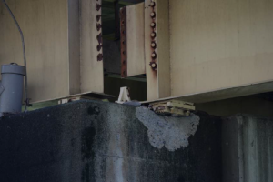 |
| Figure 8. FIgure Damage to bridge bearing (Source: Takahashi [2]) |
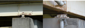 |
| Figure 9. Damage to bridge bearing (Source: Takahashi [2]) |
 |
| Figure 10. Damage to bridge bearing (Source: Takahashi [2]) |
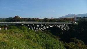
The mainshock, which occurred at 1:25am (JST) on 04/16/2016, caused further damage to bridges. After the mainshock, Aso bridge (阿蘇大橋), a 205.9m long arch bridge, was found to be completely destroyed due to a landslide. The location of Aso bridge and photos before and after the bridge failure are shown below.
 |
| Figure 11. Source: Google map |
 |
 |
| Figure 12. Aso bridge in 2009 (Source: Wikipedia [19]) | Figure 13. Aso bridge after the mainshock (Source: Kiyota et al. [9]) |
In addition to the collapse of Aso bridge, other bridges were damaged as well, such as Minami-Aso bridge (detachment of damper at the end of the bridge) [4], Choyo bridge (step at the end of the bridge) [4], Toshita bridge (failure by landslide) [4] etc. These damages are associated with ground failure.
 |
| Figure 14. Detachment of damper at the end of Minami-Aso bridge (Source: JSCE-West[12]) |
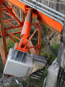
Furyo first bridge (府領第一橋) also failed during the mainshock on 04/16. This failure was caused by the buckling of the rocking pier [13]. Smaller damage to bearings was frequently observed as well, especially at expressway viaducts [7] [13].
 |
| Figure 15. Furyo first bridge after the mainshock (JSCE-West [13]) |
Concluding remarks
The severe structural damages discussed in this report can be attributed to repeated strong ground excitations. The response spectra of the foreshock on 04/14 and the mainshock on 04/16 [15] [20] show that both excitations contained a lot of energy in the range between 1s and 2s. Akira Wada, the head of Japan Academic Network of Disaster Reduction and an emeritus professor of Tokyo Institute of Technology, mentioned in a press conference on 04/18 that this type of repeated strong motions has not been taken into account in conventional seismic design practices [11]. The repeated strong motions increase damage in all types of structures significantly. Thus, more research is needed to estimate and prevent the damage caused by repeated strong earthquakes.
[1] Hata Y., “Preliminary report on the damage investigation after the 2016 Kumamoto earthquake (平成28年(2016年)熊本地震 被害調査速報[1/2], [2/2])”, http://committees.jsce.or.jp/eec205/system/files/160416hata.pdf(retrieved: 04/22/2016).
[2] Takahashi Y., “Preliminary report on the damage investigation after the 2016 Kumamoto earthquake (平成28年熊本地震 被害調査報告)”, http://committees.jsce.or.jp/eec205/system/files/%E5%B9%B3%E6%88%9028%E5%B9%B4%E7%86%8A%E6%9C%AC%E5%9C%B0%E9%9C%87%E8%A2%AB%E5%AE%B3%E8%AA%BF%E6%9F%BB%E9%80%9F%E5%A0%B1%EF%BC%88%E9%AB%98%E6%A9%8B%E3%83%BB%E4%BA%AC%E5%A4%A7%EF%BC%89.compressed.pdf(retrieved: 04/22/2016).
[3] Japan Society of Civil Engineers (JSCE)-West, “Emergency disaster report on the 2016 Kumamoto earthquake [First report](土木学会西部支部 平成28年熊本地震緊急災害報告 [速報版])”, http://iresc.kumamoto-u.ac.jp/iresc_dobokureport.pdf (retrieved: 04/22/2016).
[4] Akiyama M., “Report on damge to bridges (橋梁調査報告(2016年4月15・16日))”, http://committees.jsce.or.jp/eec205/system/files/%E6%A9%8B%E6%A2%81%E8%A2%AB%E5%AE%B3%E8%AA%BF%E6%9F%BB%EF%BC%88%E7%A7%8B%E5%B1%B1%E3%83%BB%E6%97%A9%E5%A4%A7%EF%BC%89_0.pdf(retrieved: 04/22/2016).
[5] Yamasaki F., Maruyama Y., Shoji M. and Fujisawa K., “Investigation into the 2016 Kumamoto earthquake conducted on 04/16 by an advance team (2016年熊本地震0416先遣隊調査)”, http://committees.jsce.or.jp/eec205/system/files/2016%E7%86%8A%E6%9C%AC%E5%9C%B0%E9%9C%87%28%E5%8D%83%E8%91%89%E5%A4%A7%E4%B8%B8%E5%B1%B1%E5%B1%B1%E5%B4%8E%E7%AD%91%E6%B3%A2%E5%A4%A7%E5%BA%84%E5%8F%B820160416%29.pdf(retrieved: 04/22/2016).
[6] The Japanese Geotechnical Society, “Disaster report of the 2016 Kumamoto earthquake [preliminary report] (地盤工学会 平成28年熊本地震 災害報告[速報版])”, https://www.jiban.or.jp/images/somufile/H28kumamoto_%20jishinsaigai_sokuho20160418-3.pdf (retrieved: 04/22/2016).
[7] Kuroki T. and Deguchi M., “Investigation into the 2016 Kumamoto earthquake (平成28年(2016年)熊本地震調査)”, http://www.ajg.or.jp/disaster/files/201604_kumamoto001-2.pdf (retrieved: 04/22/2016).
[8] Division of Earthquake Disasters, Disaster Prevention Research Institute, Kyoto University, “Source process of the 2016 Kumamoto earthquake (平成28年(2016年)熊本地震の震源過程)”, http://sms.dpri.kyoto-u.ac.jp/k-asano/pdf/2016KumamotoEQ_v20160417.pdf (retrieved: 04/22/2016).
[9] Kiyota T., Ikeda T. and Uchimura T., “Damage investigation after the Kumamoto earthquake, ver.2 (熊本地震被害調査 ver.2)”, http://www.gdm.iis.u-tokyo.ac.jp/20160418report2.pdf (retrieved: 04/22/2016).
[10] Yamada M., “Preliminary report on the damage caused by the 2016 Kumamoto earthquake(2016年熊本地震被害調査速報)”, http://www.eqh.dpri.kyoto-u.ac.jp/users/masumi/public_html/eq/kumamoto/ (retrieved: 04/22/2016).
[11] Japan Academic Network of Disaster Reduction, materials distributed in the press conference (防災学術連携体 熊本県熊本地方の地震に関する緊急共同記者会見資料) http://janet-dr.com/11_saigaiji/160415kyushu_kaiken/160418all.pdf (retrieved: 04/22/2016).
[12] Japan Society of Civil Engineers (JSCE)-West, “Emergency disaster report on the 2016 Kumamoto earthquake [Second report](土木学会西部支部 平成28年熊本地震緊急災害報告 [第2報])”, http://iresc.kumamoto-u.ac.jp/iresc_dobokureport2.pdf (retrieved: 04/22/2016).
[13] Japan Society of Civil Engineers (JSCE)-West, “Emergency disaster report on the 2016 Kumamoto earthquake [Third report](土木学会西部支部 平成28年熊本地震緊急災害報告 [第3報])” , http://iresc.kumamoto-u.ac.jp/iresc_dobokureport3.pdf (retrieved: 04/22/2016).
[14] Japan Society of Civil Engineers (JSCE)-West, “Emergency disaster report on the 2016 Kumamoto earthquake [Fourth report](土木学会西部支部 平成28年熊本地震緊急災害報告 [第4報])”, http://iresc.kumamoto-u.ac.jp/iresc_dobokureport4.pdf (retrieved: 04/22/2016).
[15] Goto H., “The preliminary report on the 2016 Kumamoto earthquake”, http://wwwcatfish.dpri.kyoto-u.ac.jp/~goto/eq/20160414/report_en.html (retrieved 04/22/2016).
[16] Geological Survey of Japan, AIST, “The M6.5 and M7.3 Kumamoto earthquakes on April 14 and 16,2016”, http://g-ever.org/updates/?p=214 (retrieved 04/22/2016).
[17] Ministry of Land, Infrastructure, Transport and Tourism (MLIT), “17th report on the 2016 Kumamoto earthquake (熊本県熊本地方を震源とする地震について[第17報])”, http://www.mlit.go.jp/common/001128999.pdf (retrieved 04/22/2016).
[18] Japan Meteorological Agency (JMA): (Japanese site) http://www.jma.go.jp/jma/menu/h28_kumamoto_jishin_menu.html, (English site) http://www.jma.go.jp/jma/en/2016_Kumamoto_Earthquake/2016_Kumamoto_Earthquake.html (retrieved 04/22/2016).
[19] Aso bridge (阿蘇大橋) in Wikipedia, https://ja.wikipedia.org/wiki/%E9%98%BF%E8%98%87%E5%A4%A7%E6%A9%8B (retrieved 04/22/2016).
[20] Narazaki Y., “Ground motions of the 2016 Kumamoto earthquake”, http://www.eqclearinghouse.org/2016-04-15-kumamoto/2016/04/22/ground-motions-of-the-2016-kumamoto-earthquake/ (retrieved 04/22/2016).