The mission of the Learning from Earthquakes (LFE) Program is to accelerate and increase learning from earthquake-induced disasters that affect the natural, built, social and political environments worldwide.
LFE responds to earthquakes worldwide by conducting earthquake reconnaissance and disseminating products and lessons learned. LFE's earthquake response consists of:
- Establishing Virtual Clearinghouse Websites: Reconnaissance products, including webinar recordings, reports, journal papers, data, and photos, are compiled on virtual earthquake clearinghouse websites. These websites serve as a long-term archives of lessons learned from earthquakes. View sites for over 300 earthquakes in the LFE Reconnaissance Archive.
- Activating the Virtual Earthquake Response Team (VERT): Beginning in 2015, LFE formalized a virtual earthquake reconnaissance program aimed at rapidly assessing impacts of damaging earthquakes through review of news articles and social media. The Virtual Earthquake Reconnaissance Team (VERT) provides opportunities for graduate students, early career professionals, and young faculty to be involved in post-earthquake reconnaissance. Learn More about the Virtual Earthquake Reconnaissance Team.
- Sending EERI reconnaissance teams to investigate earthquakes: Through LFE, EERI sends multi-disciplinary reconnaissance teams of earthquake risk mitigation experts to investigate earthquake impacts. Reconnaissance teams travel to earthquake-impacted areas, document important observations, and identify topics in need of follow-up research. Increasingly, LFE has focused on capturing lessons for community resilience through earthquake reconnaissance. LFE has developed a framework for resilience reconnaissance and has begun conducting follow-up reconnaissance trips months and years after damaging earthquakes.
- Coordinating international reconnaissance teams: In addition to the LFE program, there are many related organizations and private firms that also conduct earthquake reconnaissance programs. As the number of organizations that conduct reconnaissance continue to increase, EERI has led the coordination of international reconnaissance efforts. This coordination fosters collaboration, reduces duplication of efforts, and helps to minimize the burden of international reconnaissance teams on local contacts in earthquake-impacted areas.
- Participating in physical clearinghouses: For earthquakes in the US, EERI provides staffing support to operate a physical clearinghouse. A physical clearinghouse is a place where field investigators can gather to share observations and coordinate with others.
More information about how EERI responds to earthquakes can be found in the Protocols for Operations of the LFE Program (PDF).
Learning from Earthquakes is a program of the Earthquake Engineering Research Institute and is managed by a committee of experts with extensive experience conducting earthquake reconnaissance. Meet the LFE Executive Committee Members:

Eduardo Miranda,
Co-Chair

Mike Mieler,
Co-Chair

Judy Mitrani-Reiser,
Board Liaison
Erica Fischer,
VERT Co-Chair
Manny Hakhamaneshi,
VERT Co-Chair

Yu Xiao,
Business Resilience
Co-Chair
Thalia Anagnos,
Travel Study Chair
Craig Davis

Ken Elwood
David Friedman

David Frost

Jeff Hunt

Charlie Huyck
Laurie Johnson

Rob Olshansky

Rick Wilson
More details about the committee’s charge and role can be found in the Committee Charge and Organization (PDF).
EERI (LFE) and the United States Geological Survey (USGS) share responsibility under a federal post-earthquake investigation plan to manage reconnaissance efforts in the United States. EERI has primary responsibility in international earthquakes. LFE collaborates with many other partners who conduct earthquake reconnaissance around the world.
| Organization | Country | Website | |
 |
United States Geological Survey | USA | https://earthquake.usgs.gov/earthquakes/ |
 |
Federal Earthquake Management Agency | USA | https://www.fema.gov/ |
 |
National Science Foundation | USA | https://www.nsf.gov/ |
 |
National Institute of Standards and Technology | USA | https://www.nist.gov/ |
 |
Geotechnical Extreme Events Reconnaissance | USA | http://www.geerassociation.org/ |
 |
Pacific Earthquake Engineering Research Center | USA | http://peer.berkeley.edu/ |
 |
California Earthquake Clearinghouse | USA | http://californiaeqclearinghouse.org/ |
 |
Earthquake Engineering Field Investigation Team | UK | https://www.istructe.org/resources-centre/technical-topic-areas/eefit |
 |
Sociedad Mexicana de Ingenieria Sismica | Mexico | http://www.smis.org.mx/ |
 |
Applied Technology Council | USA | https://atcouncil.org/ |
 |
Structural Engineers Association of Northern California | USA | https://www.seaonc.org/ |
 |
Structural Engineers Association of Southern California | USA | https://seaosc.org/ |
 |
National Society for Earthquake Technology | Nepal | http://www.nset.org.np/nset2012/ |
 |
New Zealand Society of Earthquake Engineering | New Zealand | http://www.nzsee.org.nz/ |
 |
GNS Science | New Zealand | https://www.gns.cri.nz/ |
 |
Quake Core | New Zealand | http://www.quakecore.nz/ |
 |
EUCENTRE | Italy | http://www.eucentre.it/ |
 |
ReLUIS | Italy | http://www.reluis.it/ |
 |
Disaster Prevention Research Institute, Kyoto | Japan | http://www.dpri.kyoto-u.ac.jp/ |
 |
National Research Institute for Earth Science and Disaster Resilience (NIED) | Japan | http://www.bosai.go.jp/e/Col221:Col321 |
 |
Institute of Social Science | Japan | http://www.iss.u-tokyo.ac.jp/ |
 |
Institute of Social Safety Science | Japan | http://isss.jp.net/ |
 |
International Institute of Earthquake Engineering and Seismology | Iran | http://www.iiees.ac.ir/en/ |
 |
National Center for Research on Earthquake Engineering | Taiwan | https://www.ncree.org/ |
 |
National Science and Technology Center for Disaster Reduction | Taiwan | https://www.ncdr.nat.gov.tw/ |
 |
Asociacion Guatemalteca de Ingenieria Estructural y Sismica | Guatemala | https://www.agies.org/ |
 |
Centro de Investigacion para la Gestion Integrada del Riesgo de Desastres | Chile | http://cigiden.cl/es/ |
 |
ASCE Infrastructure Resilience Division | USA | http://www.asce.org/infrastructure-resilience/infrastructure-resilience-division/ |
| Disaster Research Center | USA | https://www.drc.udel.edu/ | |
 |
Natural Hazards Center | USA | https://hazards.colorado.edu/ |
 |
Japan Society of Civil Engineers | Japan | http://www.jsce-int.org/ |
 |
Architectural Institute of Japan | Japan | https://www.aij.or.jp/aijhome.htm |
 |
Center for Disaster Management and Risk Reduction | Germany | https://www.cedim.de/ |
 |
NICEE | India | https://www.nicee.org/ |
 |
American Concrete Institute | USA | https://www.concrete.org/committees/directoryofcommittees/acommitteehome.aspx?committee_code=C0013300 |
 |
Canadian Association of Earthquake Engineering | Canada | http://caee.ca/ |
 |
Australian Earthquake Engineering Society (AEES) | Australia | http://www.aees.org.au/ |
LFE has supported over 80 reconnaissance teams and archived information for over 300 earthquakes in 50 countries leading to advances in Structural Engineering, Earth Sciences and Geotechnical Engineering, and Social Science. Read more about the impacts of LFE in The Learning from Earthquakes Program: A Brief Synopsis of Major Contributions (PDF).
The Earthquake Engineering Research Institute has, since its inception in 1949, conducted post-earthquake investigations for the purpose of improving the science and practice of earthquake engineering and earthquake hazard reduction. In 1973, EERI formally initiated the Learning from Earthquakes (LFE) Program.
Please contact EERI LFE Program Manager, Maggie Ortiz-Millan at maggie@eeri.org with other questions related to LFE.
In 2023, EERI is marking the 50th anniversary of the formal establishment of our Learning From Earthquakes Program. Learning From Earthquakes was formally established with a grant from the National Science Foundation (NSF) in 1973. Following the impact of the 1971 San Fernando Earthquake, EERI's leadership worked with partners in the field of earthquake engineering and related disciplines to develop a framework for conducting post-earthquake investigations in order to collect perishable data and learn how to improve building standards and emergency response. As the original NSF proposal observed, “experiences of many EERI members in the investigation of destructive earthquakes, including the San Fernando shock of February 9, 1971, have developed a special expertise...EERI, through its broad range of disciplines supporting earthquake engineering, can provide experienced and effective individuals and panels for the administration, planning, and guidance of this phase.” Learning From Earthquakes grew from that original grant, funded for a single year, into EERI's flagship program, which has investigated some 300 earthquakes around the world since.
In this anniversary year, we are sharing a series of Earthquake Reconnaissance Retrospectives to mark the dates of major earthquakes in LFE's history, sharing recollections from EERI members and showcasing resources from the program's archives:
- Kobe 1995: Craig Comartin
- San Fernando 1971: Charles Thiel
- San Fernando 1971: Christopher Rojahn
- Tōhoku 2011: Terri R. Norton
- Nepal 2015: Courtney Welton-Mitchell
- Wenchuan 2008: Marshall Lew
- Oaxaca 2020 and VERT: Erica Fischer
- Kocaeli 1999: H. Polat Gülkan
- Loma Prieta 1989: Eduardo Miranda
LFE Earthquake Reconnaissance Retrospective #1: Kobe, January 17, 1995
 In January 1995, EERI and the Institute for Social Safety Science of Japan (ISSS) co-sponsored the 4th US-Japan Urban Disaster Reduction workshop that was to begin on January 17th in Osaka, Japan, about 30 km east of Kobe. The day the workshop was set to begin, participants were awakened early by very strong shaking (one participant likened it to a dog with the building in its mouth, angrily shaking it back and forth). The shaking turned out to be the devastating Hyogo-ken Nanbu (Kobe) earthquake disaster. The workshop organizers canceled all the sessions and sent participants to Kobe to record immediate observations of the earthquake damage. EERI members recall walking toward ever more distressing scenes of destruction. Their observations formed the basis for the EERI Kobe Reconnaissance report. Below, Craig Comartin (M.EERI 1987), one of the EERI members attending the workshop, reflects on the earthquake impacts and recounts major lessons learned from the earthquake.
Kobe 1995: A personal account by Craig Comartin
The most devastating earthquake to hit Japan since the 1923 Tokyo earthquake occurred at 5:46 A.M. local time on January 17, 1995 exactly a year after the Northridge earthquake. Over 5,000 people were reported killed, more than 26,000 people were injured, and over 300,000 people were left homeless. At the time of the earthquake, about 40 American engineers, scientists, and government officials were in Osaka, 30 km east of Kobe, for a joint U.S.-Japan Workshop on Urban Earthquake Hazard Reduction, co-sponsored by the Earthquake Engineering Research Institute (EERI) and the Japan Institute of Social Safety Science (ISSS), and funded by National Science Foundation (NSF). The workshop participants immediately undertook preliminary post-earthquake reconnaissance efforts. I was part of the US side in this effort. I was also fortunate to return to Kobe several times during the ensuing months and years.
 The Great Hanshin Earthquake, as it is also known, is an important record of the effects of earthquakes on modern high density cities and surrounding areas.
So what did we learn from the Kobe earthquake?
Much of the damage deaths and injuries were caused by a conflagration of fires that burned quickly through the densely populated (approximately three times more dense than Oakland, California as an example) and the light wood frame construction typical of Japanese houses, The making of plastic shoes was a cottage industry in Kobe. The materials used were highly flammable and most households used kerosene heaters that ignited them during the earthquake. Additionally we witnessed the now proverbial importance of housing displaced individuals and families after the event.
Kobe today is not the city it was prior to the earthquake. The economic impacts of the earthquake were substantial. The port of Kobe has never fully recovered. Part of this is due to the critical transportation corridor between Osaka and Kobe that was severely disrupted with bridge and highway interchange structures collapses that took years to repair or replace.
The 7.2 magnitude event occurred on a strike slip fault that had a bilateral rupture of approximately 40 km. Liquefaction induced subsidence, and ground displacement were pervasive In the reclaimed lands along the margins of Osaka bay, Quay walls failed throughout the port. These factors contributed significantly to the damage of port facilities.
 City planning even in the United States is a chaotic process at best. There are city planning guidelines in Japan, but these are often not enforced systematically. In Kobe, poor planning, and development contributed to the effects of the earthquake. Streets and Kobe are very narrow hampering, emergency vehicles, including ambulances, and fire fighting equipment.
Japanese construction practice for buildings contributed to the severe damage or collapse of both commercial and residential buildings. For example, Japanese houses typically have clay tile roofs and dry rot, and pest infestation is widespread. Building codes at the time of the earthquake allowed practices that contributed to the poor performance of new construction of relatively large commercial buildings.
Railways are a vital component of transportation in Japan. Both the Shinkansen (high speed train) and other railroads were severely damaged and closed. Kansai international airport was located 30 km from the epicenter on a man-made island. The island settled over a foot but no damage was found in the airport facilities themselves, and the runway remained operational. Overhead utilities, comprising, electrical and telecommunications, fared well. In contrast, buried utilities, including wastewater, gas, and freshwater suffered extensive damage throughout Kobe.
Several major hospitals were extensively damaged. However, many doctors’ offices remained open and allowed for treatment of relatively minor injuries. It was also noted that many people having lost their home, possessions, and neighborhood communities suffered from PTSD.
These lessons learned from the Kobe earthquake have been captured and preserved in the LFE earthquake archive. The current LFE database is a valuable tool for professionals and academics. In my opinion, this program defines EERI‘s purpose and soul, notwithstanding, mission statements, and goals on record. It is our responsibility to improve it with continuous effective curation. Several years ago, along with other former officers and directors of EERI, I made a pledge to support LFE. Today, all members can contribute at any level. This allows all members, including those at an early stage of their career development,to contribute. You will be receiving more information in the near future about ways to contribute to LFE in its 50th year. I sincerely hope that you will take advantage of this opportunity to maintain and improve the learning from the Learning from Earthquakes program at EERI.
Craig Comartin
M.EERI 1987; President 2005-2006

Photos, top to bottom: excerpt from EERI's February 1995 newsletter; rail facility damage and fires in Kobe; building damage in Kobe; Craig Comartin atop UC Berkeley's Sather Tower.
More information
The LFE earthquake page for Kobe showcases a range of information and resources about the earthquake, including newsletter articles, reconnaissance reports, photo slide collections, Spectra articles, and more. Here are a few highlights:
- ”Kobe, Japan, Devastated by M.68 Quake—Large EERI Group in Osaka for Workshop Undertakes Preliminary Reconnaissance Work,” EERI Newsletter, February 1995
- “Lifelines Suffered in Kobe Quake,” EERI Newsletter, May 1995
- The Hyogo-ken Nanbu (Kobe) Earthquake, January 17, 1995: Preliminary Reconnaissance Report, by Craig D. Comartin, Marjorie Greene, Susan K. Tubbesing
- Lessons Learned from the Kobe Earthquake - A Japanese Perspective
- Image Slide Collection 6: Repair and Reconstruction of Historic Landmarks (Photos)
LFE Earthquake Reconnaissance Retrospective #2: February 9, 1971 San Fernando Earthquake
On February 9, 1971 at 6:01 am PST, a M6.6 earthquake struck San Fernando, California, in the foothills of the San Gabriel mountains on the outskirts of greater Los Angeles. 65 people were killed and over 2000 injured, and there was extensive damage to hospitals, freeway interchanges, and the Lower Van Norman Dam. The San Fernando earthquake had a transformational impact on earthquake engineering research, policy, and practice in the United States—and led directly to the creation of the Learning From Earthquakes Program. The following year, EERI President C. Martin Duke submitted a proposal to the National Science Foundation titled “Development of a Plan to Maximize the Learning from Destructive Earthquakes,” which observed that “progress in earthquake engineering is more strongly influenced through experiences in destructive earthquakes than in any other way. The recent San Fernando earthquake provided a one million dollar uncontrolled experiment. It is therefore of the highest importance to maximize the learning from future quakes. The Earthquake Engineering Research Institute (EERI) proposes to develop a plan to maximize the collection and dissemination of critically needed information emanating from destructive earthquakes.” Below, Charles Thiel (M.EERI 1973), shares a behind-the-scenes account of how the San Fernando earthquake led to the creation of a vibrant reconnaissance community and the founding of Learning From Earthquakes, and Christopher Rojahn (M.EERI 1973) provides an overview of the NOAA/EERI reconnaissance studies of San Fernando and their impact on seismic codes and the creation of the Applied Technology Council (ATC).
The 1971 San Fernando Earthquake and Learning From Earthquakes: a personal account by Charles Thiel
San Fernando occurred in February 1971. I had just gone to work for NSF the previous fall, in the engineering mechanics program. When the quake occurred, I was the most recent hire, working for Mike Gaus and his assistant Charlie Babendrier. I was the third man on the totem pole, but the only one with a background in earthquakes and structural dynamics.
 When the earthquake occurred, Charlie had just started 5 weeks of parental leave, and Mike had left on a mission to Yugoslavia for a month or longer. So I was the only one holding down the fort. We had no plan, as it was at that time an organization that responded to proposals for research support. The day after the earthquake, I got a call from George Housner, and he told me “There’s a crisis out here—we’re going to lose the strong motion records because NOAA doesn’t have any money and they aren’t going to pick up the records until the new budget year, after July 1. Can’t you do something?” I called some other people, and what became clear was that there was no support program for people investigating earthquakes who weren’t federal employees, and in NOAA’s case had no reserve to collect records. And the USGS was interested in geophysical records and geological impacts, not structures. I went to my Division Director, John Ide, and I said “We’re going to lose these records—we’ve got to get this data. We need money.” He said division funds were fully committed and to see if I could move some money from an existing CalTech contract, and approve it for this purpose—and amount available were peanuts, but I did it anyway. I called George Housner (one of the founders of EERI) and Don Hudson and we managed to get the guys from CalTech to go out and collect some of the records to the extent possible. Most of the instruments were in private buildings, placed there because of the building code in Los Angeles, and some were NOAA’s. So, we solved that first problem on the second day. It took me writing the proposal, with the approval of Caltech, and my administration turning a blind eye.
Beyond that, though, the funding for the fiscal year for earthquake engineering had been spent. So, in absence of any way to do field research, I went to the Deputy NSF Director, Raymond Bisplinghoff, a distinguished aeronautical engineer from MIT. It turns out that for an assistant program manager to do that was a faux pas—it’s just not done in large bureaucracies and especially at NSF—but luckily, I didn’t know that at the time. I told him that if we were going to make anything of the earthquake engineering program, we needed to get this data now and investigate how and why the damaged and undamaged buildings had reacted as they did. I had read so many investigations of historic earthquakes, and they had lots of damage pictures, but rarely any follow-up to understand what had occurred. I argued that we missed this boat in Anchorage in 1964, and we could not be certain the opportunity would present itself again for decades. I made a plea for instant money for the program. He asked how much, and I thought about it for a moment and said, as I recall, “A million and a half dollars, as soon as practical—in a month or less.” Lo and behold, the next day I found out I’d gotten it.
 I called George Housner and said we have ten days to put this together—to convene a group of investigators and decide on topics and assignments. I flew out to Los Angeles. We collected all the top engineering guys active in earthquake research nationally—at least 4 past, current, or future presidents of EERI were at the table. We had maybe as many as 25 people there. We developed a program, and within a few weeks they had all written proposals and they were funded. These proposals were processed in less than a week, and people were in the field, many on the promise of funds to catch up, well before that. When I left NSF eight years later, several folks in the grants office said they had been getting even with me since for the amount and speed of work that let the San Fernando response be so successful.
One of the things we focused on was that we had to learn what we needed to learn. Karl Steinbrugge at the Pacific Fire Rating Bureau had written an important pamphlet on earthquake investigation a year or two earlier, but no one had been able to put real money behind the effort until this point. Historically, they were the ones who wrote in-house reports for insurance rate needs that the engineering community relied upon.
We went balls out, if you’ll excuse the term—to get as much done as we could. And we did. As we went about it the questions were asked about how we could be better prepared and get people quickly into the field, to be ready to deal with the next earthquake. These events come along relatively sparsely—since then, there have only really been two of the same level in the U.S., Loma Prieta and Northridge. So, we spent some of the money to support an effort to do preplanning. We knew we needed more than just an engineering view—I wanted to look at the rest of the problems, like land use planning, emergency response, and the whole sphere. In that meeting and later on, I had several discussions with Martin Duke, who was then the EERI president, about how we needed more than just this response—to have enough momentum to sustain what we’d started, we need to secure long-term funding.
 To accomplish this, I would need an open membership organization, to act as a public advocate. In my view, EERI was the obvious choice. EERI was just a selected members-only group of 100 at the time. He wasn’t sure the members would be on board, but he took this back to the Board and got them to agree, and to make EERI a real membership organization open to everyone, as it is today. The second problem was even more pressing: we needed an administrative strategy, to make sure we had people who knew about things like the building codes and the architecture and so on involved ahead of time before the next earthquake came. We laid it all out, and I said go write a proposal, which Martin did and that was the beginning of “Learning From Earthquakes”, for which we are now celebrating the 50-year anniversary.
The essential thing was that right after the earthquake, I was in a position to start this effort and fortunately, Mike said to run with it, so I had buy-in to invest in non-engineering researchers that could make it happen, even in an engineering division. We supported a planner at Cornell, an architect in Berkeley, a geographer in Colorado… I’m an engineer, with a strong science background. From my perspective, the key to pulling it all off was that we didn’t treat it first and foremost as a pure research program, but as a source of solutions—we focused on using the learning we were advancing. So all our subsequent grants required utilization plans: that is, how were the researchers going to make sure the intended users of their results had access to what they learned? We provided funds for participation on Building Code related work were appropriate. After a big earthquake, the tendency is always to focus on losses, but we had to make the argument for the potential gains of preparing technology and practice methods to make the future safer. We established an interagency committee and reached out to USGS, so it became a united program. Within six years, the constituency had been built and we had $70 million in funding, as I recall, for the NSF earthquake engineering program, the USGS, which had absorbed the old NOAA seismic instrumentation program, and the President’s Office of Emergency Services. And it was all because of that initial year and a half right after the earthquake occurred. It took five years, but through constant effort of the community established, Congress acted, and gave the entire earthquake hazards program a constitutional endorsement.
And it has been sustained. LFE was an initial building block, along with the Applied Technology Council, which had a similar NSF stimulus that we initiated, growing out of the same opportunities. It also prospered in advancing earthquake mitigation, an even more important aspect of the post-San Fernando Earthquake response, as did the emergency response functions, which finally triggered the formation of a stable response agency, FEMA. I am proud to see that these early efforts have matured to become essential parts of our work to ensure better management of earthquakes than the historical norm. It was an honor to have contributed to this process.
A final comment: this experience also changed the NSF. There had been an innovative program called goal-oriented application research support that was a once-off effort. NSF used the San Fernando effort to help win Congressional support for a new initiative, Research Applications for National Needs (RANN). The earthquake program was incorporated into the new RANN and prospered—after 6 years, it had more than 10 times the level of support that was as the initial allocation that San Fernando generated. And the Earthquake Hazards Mitigation Program survived the reorganization of RANN and its absorption into other NSF elements and prospered.
Charles C. Thiel, Jr., PhD
M.EERI 1973

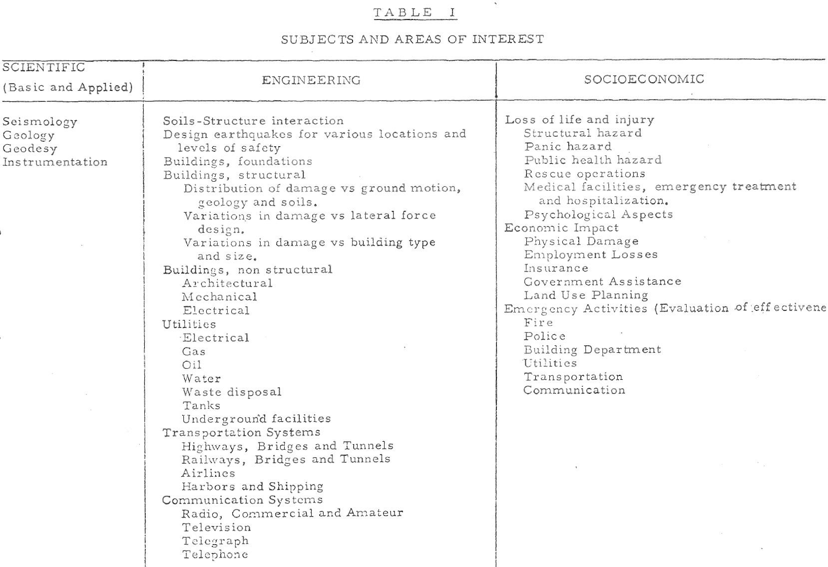
Images, top to bottom: Damage to a Los Angeles freeway in 1971 (Los Angeles Times/California Geology); Collapse of Sylmar Veterans Hospital (California Geology); Table 1 of "subjects and areas of interest" from EERI's 1972 NSF Proposal; Charles C. Thiel.
EERI’s Significant Involvement in Studies of the 1971 San Fernando Earthquake: a personal account by Christopher Rojahn
The San Fernando, California, earthquake of February 9, 1971, a moderate-magnitude earthquake in a developed area, was a pivotal event in several important respects: (1) it caused unexpected severe damage to buildings and other structures that had been designed to resist earthquakes; (2) it served notice that existing seismic design codes in the United States were inadequate and in need of improvement; and (3) it inspired a comprehensive study that is unparalleled in many respects and a model for generations to come. The study was carried out by earth scientists within the National Oceanic & Atmospheric Administration (NOAA), the U. S. Geological Survey, and other agencies/universities, and by the Earthquake Engineering Research Institute (EERI), under a previously arranged contract with NOAA that was implemented immediately after the 1971 earthquake. EERI had responsibility for studying the effects of the earthquake on the built environment and on society as a whole. The studies were designed and led by Leonard Murphy (Scientific Coordinator, NOAA), Martin Duke (EERI President and Professor, Dept. of Civil Engineering, University of California at Los Angeles), Karl Steinbrugge (Manager, Earthquake Department, Insurance Services Office), and Don Moran (Consulting Structural Engineer and EERI Vice President). My job, as Field Coordinator for the NOAA Study and NOAA Liaison Representative (to/with EERI), commenced within days after the earthquake when I was still an officer in the NOAA Commissioned Officers Corp. As Field Coordinator and NOAA Liaison Representative, my role was to coordinate and review the studies being conducted by EERI, and to oversee the preparation of all engineering report line drawings prepared by graduate students at the University of California, Berkeley. The headquarters for the EERI engineering studies (and my office), arranged by Martin Duke, were located at the University of California at Los Angeles (UCLA) within facilities occupied by the Civil Engineering Department in Westwood, California.
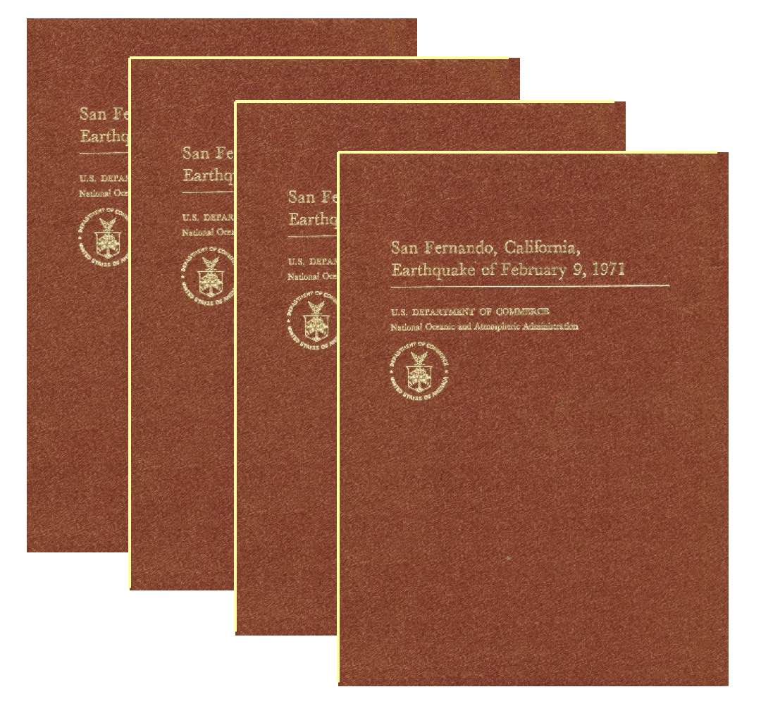 The NOAA/EERI Study of the 1971 San Fernando is documented in a three-volume set entitled San Fernando, California, Earthquake of February 9, 1971, which was published in 1973 by NOAA, U.S. Department of Commerce. Volume I (841 pages in two parts, Parts A and B), contains studies on buildings and soils and foundations; Volume II (325 pages) contains studies on utilities, transportation systems, and sociological aspects; and Volume III (432 pages) contains geological and geophysical studies, including papers describing (a) the several hundred strong-motion records obtained from accelerographs operated by the Seismological Field Survey of NOAA at ground sites and in buildings throughout the region and (b) the subsequent accelerogram processing and analysis program of those records, which was conducted largely at the California Institute of Technology with funding from the National Science Foundation. As noted in the introduction to Volume I, the principal intent of the NOAA/EERI San Fernando earthquake volumes was “to bring together the vast quantity of information obtained during postearthquake field investigations and studies and to provide the best possible engineering and scientific analyses as soon as possible after the event.”
All types of affected buildings were studied by EERI, including low-rise commercial and industrial buildings, detention facilities, hospitals and medical facilities (including the severely damaged Olive View Hospital), high-rise buildings with strong-motion instruments, high-rise buildings without strong-motion instruments, non-earthquake-resistant buildings, and public school buildings. The report on each building in Volume I followed the same format and included: descriptions and representative photographs of the damage; a description of the criteria used in the seismic design of the building (if applicable); drawings of floor plans, elevation and section views, and structural details in sufficient detail to fully represent the lateral-load resisting system; conclusions on the cause(s) of damage, and repair strategies, if applicable. In addition, the studies of the eleven high-rise buildings with strong-motion instruments contained copies of the strong-motion data and results from consistently applied dynamic analyses designed to uncover the dynamic lateral loads sustained by each building in comparison to the seismic design loads. The specifications for the dynamic analyses of instrumented buildings and the format for presenting the results were formulated by an EERI committee chaired by Bill Gates (Structural Engineer with Conrad Associates, Los Angeles).

The NOAA/EERI study of engineered buildings served as one of the primary catalysts for changes in seismic code provisions in the 1973 and 1976 editions of the Uniform Building Code, which governed the design and construction of buildings in the high seismicity regions of the western United States, including California. The changes to provisions for certain building types (wood-frame buildings, steel frame buildings with cast-in-place concrete shear walls, concrete moment-resisting frame buildings, concrete shear-wall buildings, and reinforced masonry buildings with rigid floor and roof diaphragms) were so significant that the year in which they were implemented (1976) is deemed a “benchmark year” by existing hazard mitigation documents prepared by the Applied Technology Council and published by the Federal Emergency Management Agency and by other seismic risk tools.
Importantly, not only was the poor performance of engineered buildings and other structures during the 1971 San Earthquake a catalyst for the establishment of EERI’s Learning From Earthquakes (LFE) program in 1973, it also served as the catalyst for the establishment of the Applied Technology Council (ATC), which was founded and incorporated in 1973 to advance the practice and technology of structural engineering. And like the LFE program, ATC is now celebrating its 50th year. On December 8, 2023, ATC will be hosting its signature anniversary event, ATC at 50: Celebrating the Past, Engaging the Present, and Envisioning the Future, which will include a retrospective and visionary technical session followed by a celebratory black-tie-optional ATC Awards dinner that evening at the same location, the Hyatt Regency San Francisco. EERI members are encouraged to attend!
Christopher Rojahn
M. EERI 1973; Board Secretary 1977-1981
Images, top to bottom: the four-volume NOAA-EERI report on the earthquake; the severely damaged Olive View Hospital, medical treatment and care unit, located 6 miles from the epicenter of the 1971 San Fernando Earthquake and designed in accordance with the 1965 Los Angeles County Building Code—note the heavily damaged exterior tied columns at the first-floor level, collapsed 5-story stair tower (center right of photo), and collapsed ambulance canopy (lower left of photo); Christopher Rojahn.
More information
More information about the 1971 San Fernando Earthquake is available on the LFE event page here. Resources include:
- Development of a Plan to Maximize the Learning from Destructive Earthquakes (original NSF proposal, PDF)
- Preliminary Engineering Findings from Los Angeles Earthquake of February 9, 1971 (EERI report, PDF)
- Reflections from the EERI Oral History Series on the 1971 San Fernando Earthquake (video presentation by Thalia Anagnos)
LFE Earthquake Reconnaissance Retrospective #3: March 11, 2011 Tōhoku Earthquake and Tsunami
The Tōhoku or Great East Japan earthquake and tsunami struck on March 11, 2011. The M9.0 earthquake—the strongest ever recorded in Japan—occurred at 2:46 p.m. local time about 70 kilometers offshore. Tsunami waves began to impact the coastline roughly 10 minutes later, and the inundation cycle continued for several hours. The disaster resulted in 19,759 deaths and the displacement of hundreds of thousands of people. EERI’s Learning From Earthquakes program sent multiple reconnaissance teams to Japan in the aftermath of the disaster. Among them was an 11-member multidisciplinary team studying societal and governmental response in collaboration with Japan’s Institute for Social Safety Science (ISSS). Below, Terri R. Norton recalls her reconnaissance experience as the sole engineer on this societal dimensions team, which was in the field from June 19-26, 2011.
Tōhoku 2011: A personal account by Terri R. Norton
I already had reconnaissance experience prior to the Tōhoku earthquake and tsunami—as a graduate student, I participated in a Tri-Center, MCEER, MAE Center, and PEER reconnaissance visit to Italy in 2003 to study the impacts of the 2002 Molise earthquake. I’m from Florida, so I had done a lot of post-hurricane reconnaissance as well. When I became a professor, I wanted to continue doing reconnaissance, and I thought I’d focus on structural assessment and engineering since that was my background. At an EERI meeting, I attended a Learning from Earthquake session that included a lot of conversation about having younger members on reconnaissance teams, which inspired me to apply. But in practice, it was really challenging to get onto a team. It became a lesson in perseverance—the structural engineering teams never said yes to me, which was discouraging at first. It was actually a societal dimensions team that welcomed me and finally gave me the opportunity to join an EERI reconnaissance mission.
 I’d been talking with Marjorie Green about the Tōhoku reconnaissance trip. I had previous experience in Japan—I’d spent summers there with the NSF REU Program in Japan in Advanced Technology and NSF East Asia and Pacific Summer Institutes for U.S. Graduate Students Program, and this time I also had my own funding to go. So I became the only engineer in the group that traveled to Japan about three months after the 2011 earthquake and tsunami to conduct reconnaissance on the societal dimensions of the disaster. And it actually ended up being the most rewarding experience for me, because it informed what my work would become moving forward. I was already interested in the topic of debris, but from a structural angle—and now here I was with social scientists, urban planners, emergency management specialists, and policy experts, and that allowed me to get out of my box and see the disaster from a more humanistic point of view. It forced me to really see that this was not just about the built environment—it is also about community, about the people who live in the buildings—and it pushed me to ask how the work I was doing was going to help them build back better.
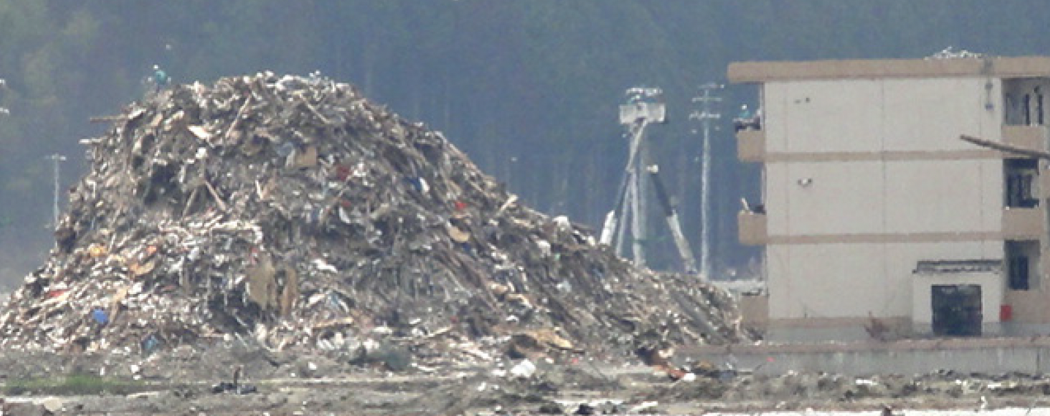
It’s unreal to see that level of devastation—I’d seen earthquake damage in Italy, but this was almost like something out of a film. We saw things like a boat perched on top of a hotel, or areas where just the footprints of foundations were visible. On that trip, the only place where we really observed damage from the earthquake was in Sendai, such as damage to a multistory apartment building.  Otherwise, at all eleven sites we visited, the tsunami was the cause of the destruction. We saw the results of inundation, direct tsunami impacts to structures, and others that had been damaged or destroyed by other buildings as they were washed away. The scale of a disaster like that is something you never forget. Many of the areas we visited were ghost towns—often we would be the only people there, or sometimes we’d just see the workers who were clearing debris, but no residents. Even when I went back a few years later, many of these areas were still quite desolate. In a lot of fishing towns, like Otsuchi, older residents remained, but younger people moved away.
The question that interested me was: how can we recycle this debris and use it to build structures? Traveling with scholars like Kathleen Tierney, Rich Eisner, Laurie Johnson, and Tricia Wachtendorf, and on a mission where we were also visiting evacuation sites and talking to individuals in shelters, helped me see the broader ecosystem involved in an event like Tōhoku and recolored the way I view disasters in my work. For example, when I think about recycled materials, now I’m not just looking at the mechanical properties or salvageability criteria, I’m thinking about the kinds of values they have for people—the religious, cultural, family, and personal significance of those materials and what it means.
 Japan also had a long history of recycling and reusing material from earthquakes, both for rebuilding and land reclamation. They were ahead of the curve in that respect—in some of the areas we visited, I learned that the existing municipal recovery plans included debris management and recycling. In Sendai, they had plans for how to stand up facilities, to sort, recycle, and reuse materials. But tsunami waste and sediments were a new problem. So they were exploring ways to reuse that waste for future mitigation—like building embankments for coastal protection, or land elevation for vulnerable communities, and raising the elevation of roadways to create better evacuation routes.
The connections with Japanese researchers I developed on that trip laid the groundwork for more, including the Fulbright U.S. Scholar Program grant I was awarded in 2016. One of them actually ended up being my Fulbright host. And I developed a new understanding of the value of interdisciplinary work. For LFE, having a diverse group in the field adds value both for the reconnaissance team members and the communities we engage with.
Dr. Terri R. Norton
Associate Dean for Students and Strategic Initiatives and Professor of Civil & Environmental Engineering, Bucknell University
M.EERI 2004; Vice President, EERI Board of Directors

Images, top to bottom: the 2011 EERI Societal Dimensions reconnaissance; tsunami damage in Ishinomaki City (Lori Dengler); debris pile in Rikuzentakata City (Terri R. Norton); Terri R. Norton pictured amid tsunami debris.
More information
More information is available at the LFE's Tohoku, Japan Earthquake and Tsunami Virtual Clearinghouse. Some additional resources include:
- “The March 11, 2011, Great East Japan (Tohoku) Earthquake and Tsunami: Societal Dimensions”“The March 11, 2011, Great East Japan (Tohoku) Earthquake and Tsunami: Societal Dimensions” report by Stephanie Chang, Daniel Aldrich, Richard Eisner, Laurie Johnson, Terri Norton, Kathleen Tierney, Tricia Wachtendorf, Rochelle Brittingham, Kanako Iuchi, Sahar Safaie, and Jay Wilson (PDF)
- “The Road to a New Tohoku: Rebuilding after the 2011 Great East Japan Earthquake and Tsunami,” Terri R. Norton, Mid-America Transportation Center (MATC) Scholars Conference, 2017 (video and transcript)
- Earthquake Spectra Volume 29 Issue S1 (2013): 2011 Tohoku-Oki Earthquake and Tsunami
- The Japan Tohoku Tsunami of March 11, 2011 by EERI, Earthquake Research Institute (Japan), and International Tsunami Survey Teams (PDF)
LFE Earthquake Reconnaissance Retrospective #4: April 25, 2015 Gorkha Nepal Earthquake
 On Saturday, April 25, 2015 at 11:56 local time, a 7.6 magnitude earthquake struck the Gorkha district of Nepal, about 85 kilometers north-west of Kathmandu. Dozens of aftershocks followed, including a 6.7 magnitude earthquake the following day. The earthquake killed nearly 9,000 people, the vast majority of them in Nepal, and also caused fatalities in India, China, and Bangladesh. According to the National Society for Earthquake Technology-Nepal (NSET), over half a million homes were damaged or destroyed. Learning From Earthquakes sent a 13-person multidisciplinary reconnaissance team to Nepal a little more than a month after the earthquake. Below, Dr. Courtney Welton-Mitchell, assistant professor at the Colorado School of Public Health and co-chair of the LFE Public Health Subcommittee, reflects on her experience as a member of that team.On Saturday April 25, 2015 at 11:56 local time, a 7.6 magnitude earthquake struck the Gorkha district of Nepal, about 85 kilometers north-west of Kathmandu. Dozens of aftershocks followed, including a 6.7 magnitude earthquake the following day. The earthquake killed nearly 9,000 people, the vast majority of them in Nepal, and also caused fatalities in India, China, and Bangladesh. According to the National Society for Earthquake Technology-Nepal, over half a million homes were damaged or destroyed. Learning From Earthquakes sent a 13-person multidisciplinary reconnaissance team to Nepal a little more than a month after the earthquake. Below, Dr. Courtney Welton-Mitchell, assistant professor at the Colorado School of Public Health and co-chair of the LFE Public Health Subcommittee, reflects on her experience as a member of that team.
Nepal 2015: a personal account by Courtney Welton-Mitchell
At the Colorado School of Public Health I teach about climate and disaster mitigation, preparedness, response, and recovery, but my background is in traumatic stress studies, as a clinical mental health provider and a humanitarian aid worker. I became part of the LFE reconnaissance trip to Nepal because of this interdisciplinary background, but also because I have a long history working in Nepal. I was deployed as a Peace Corps volunteer in Nepal in 1998, and I stayed on afterwards and worked with the World Food Programme. I lived in Nepal for eight or nine years in total, and speak Nepali. I was also doing research in Nepal in 2015, as part of a grant to study mental health-integrated disaster preparedness innovations in Haiti and Nepal. We were working in three flood-affected communities in Kailali district, with our local partners Transcultural Psychosocial Organization of Nepal (TPO Nepal). I was there on a research visit for this project just a few weeks before the April 25th earthquake struck.
When the earthquake happened, a few things occurred simultaneously. I am affiliated with the Natural Hazards Center at CU Boulder, and colleagues there were affiliated with EERI—before the 2015 earthquake, I had no connection with EERI. My colleagues told me EERI was planning reconnaissance and wanted to have a social scientist on the team—would I be interested? So I said yes, and once I was selected to participate I rapidly scrambled to learn more about reconnaissance. At the same time, we were interested in expanding the work we’d been doing in Kailali district, which was not affected by the earthquake, to the communities that were impacted, and were seeking additional funding for that. Those local partnerships played an important role—one of the first things I did once I was added to the reconnaissance team was to invite a colleague with a social work background, Rubina Awale, to join as my Nepali counterpart.
 The reconnaissance mission took place from May 31 to June 8, and during that time we visited Kathmandu, Lalitpur, Bhaktapur, Kavre Palanchok, and Sindhupalchok districts. The team also split up into a few subgroups to focus on different areas and topics—for example, Judith Mitrani-Reiser led a group that went to another district to look specifically at hospital infrastructure. I was traveling with engineers, and they were looking at the structural integrity of buildings, the causes of building failures, and the tagging work done by NSET and the Nepalese military, as well as geotechnical impacts like landslides and liquefaction. At the time, I assumed my role in the reconnaissance effort was to focus on things that might be relevant to the topics the engineers were interested in—but also, and perhaps more importantly, to contribute in ways that broadened the lens beyond an engineering perspective. So I focused on social, psychological, and cultural factors. This was a rapid and somewhat ad hoc assessment, and our goal was to lay the groundwork for future research by getting a snapshot and identifying the areas of importance. During the trip, I was able to do semi-structured informal interviews with about 80 community members, government officials, and relief agency staff.
We interviewed community members and other stakeholders, and investigated eight topics of interest, such as disaster attributions—by which I mean the explanatory frameworks people use to understand the causes of earthquakes and other disasters. We also asked stakeholders about mental health and coping, and social support/cohesion and conflict. We talked to local communities about topics like remittances and livelihoods, relief aid mechanisms, sociopolitical issues around governance and how they map onto the history of the civil war in Nepal, and issues of gender, caste, ethnicity, language. trying to lay the groundwork for future research along those areas. We wanted to get a sense of community perceptions around these topics and how they intersected with the things the engineers were studying. I was particularly interested in disaster attributions and the implications those had for preparedness interventions, because there are significant cultural components to that topic. There’s a lot of heterogeneity in Nepal, maybe more so than any other place I’ve worked—not just in terms of things like age, education, and rural/urban divides, but also when it comes to the range of ethnic groups and subgroups and religious beliefs. For example, older people in rural settings with higher religiosity were more likely to say the earthquake happened because people weren’t as pious as they used to be, or didn’t do appropriate ceremonial preparation of the ground before they started building their residences.
 The experience I gained from participating in the reconnaissance had direct and immediate implications for what I was able to do in terms of the follow-on research. With colleagues in Nepal and the team working in Haiti, we did secure additional funding to collect data from earthquake-affected communities, adapt the intervention we were using in Kailali, and implement and evaluate it. That was a very useful exercise, and I think the recommendations for future research we made were valuable, especially on topics like the importance of disaster attributions in preparedness and rebuilding, or the mental health aspects and how their implications extend far beyond what we think of as a clinical psychology lens, to issues like how people engage with recovery and reconstruction and how responsive they are to interventions. We also looked at topics like the economic impact of the devastated tourism sector, and how relief aid mechanisms worked in practice. One area that I wanted to see researched further was how the level of community cohesion affected the rebuilding process, including access to aid—our conversations during the reconnaissance suggested that more homogenous communities had a head start on the rebuilding process because of strong mutual aid networks and were also more able to leverage the process of getting government relief, whereas more diverse communities may have struggled.
The experience also prompted me to consider how we might have approached the reconnaissance effort differently. Coming from a clinical mental and social psychology perspective, I wasn’t always entirely sure how best to integrate the data collection I was doing with that of the engineers on the team. Now that I’ve spent several years teaching in a school of public health and become part of the LFE public health subcommittee, I am much more aligned and integrated with the type of questions that are of immediate and long-term interest to my colleagues in engineering. For example, why would people choose not to evacuate a yellow or red-tagged building? Looking back, I felt like I was sort of working in isolation, although I was getting all this rich information from local communities and also learning a lot from the other team members. This has led me to think that we need to do a better job of integrating approaches like the social determinants of health model with the engineering aspects of reconnaissance. We can advocate for engineers to engage with other disciplines and vice versa, but I think the more challenging and important piece is actually figuring out how to navigate the overlap in our fields of inquiry.
When the Public Health Working Group (now the Public Health Subcommittee) was formed, we had to figure out how to integrate with LFE and EERI—were we looking to recruit engineers with a public health lens, or recruit public health specialists that could then inform engineers, for example by being embedded in reconnaissance teams? Thinking through these questions was what led us to develop the post-earthquake social determinants of health data collection tool. This tool is a framework we published on DesignSafe for looking at pertinent questions in reconnaissance around housing, water sanitation, living conditions, health services, employment education, and food security—topics that map onto social determinants of health domains.
But if you’re an engineer and you’re going on reconnaissance, it’s difficult to just adopt the framework without additional context and a detailed questionnaire. So an MPH student here, Shaya Christensen, is working on a project to improve the assessment tool, focusing on the hospitals and health services component. Public Health Committee Co-Chair Luis Ceferino is currently in the process of pilot-testing new hospitals and health systems components of the Social Determinants of Health Tool in post-earthquake reconnaissance in Turkey with EERI and other partners, utilizing a questionnaire that Shaya helped to construct. In addition to doing in-person interviews with engineers, Shaya has created an online survey for those with reconnaissance experience or interest to gather feedback and information on how the tool can be used in practice. The results will not only inform how the data collection tool is structured, but will also shape the methodological approaches, guidelines, best practices, and ethical considerations for those using it in the field. The goal is to make something that brings engineers and social scientists and public health professionals into alignment, on both the data collection and data use sides of post-earthquake reconnaissance. If you have participated in reconnaissance and want to help to improve the tool, please complete the survey! Shaya will be collecting responses through May 20th.
Courtney Welton-Mitchell
Co-Chair, LFE Public Health Subcommittee
Assistant Professor and Director (Certificate in Climate & Disaster Resilience), Colorado School of Public Health

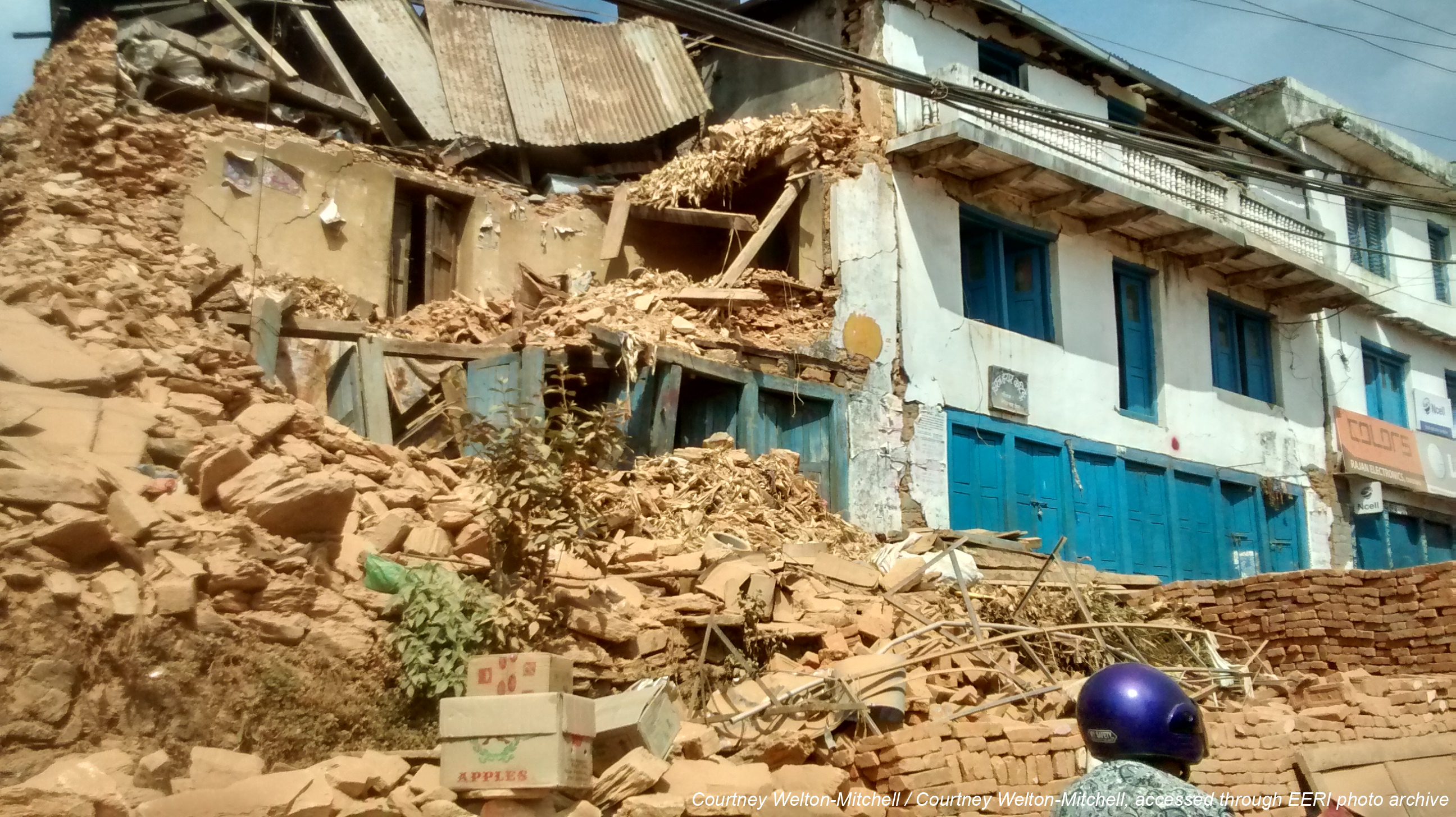
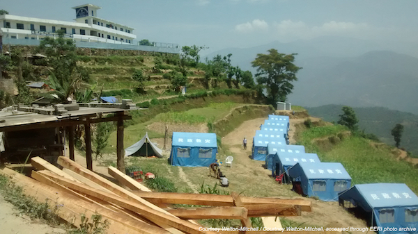
Images, top to bottom: Building damage in Kathmandu (Hemant B. Kaushik); rubble near the bazaar in Chautara (Courtney Welton-Mitchell); tents for post-earthquake shelter near Chautara (Courtney Welton-Mitchell); Courtney Welton-Mitchell.
Resources
- LFE 2015 Nepal Earthquake Clearinghouse
- Social, Psychological and Cultural Factors: Implications for Disaster Preparedness and Rebuilding (video presentation by Courtney Welton-Mitchell for the LFE Nepal reconnaissance briefing series; slides available here).
- M7.8 Gorkha, Nepal Earthquake on April 25, 2015 and its Aftershocks (LFE Reconnaissance Report)
- Welton-Mitchell, C., James, L., & Awale, R. (2016). Nepal 2015 Earthquake: A Rapid Assessment of Cultural, Psychological and Social Factors with Implications for Recovery and Disaster Preparedness. International Journal of Mass Emergencies & Disasters, 34(3), 399–418. https://doi.org/10.1177/028072701603400303
- Errett, N., A. Kossik, M. Archer, L. Ceferino, L. Clay, K. Eid, A. Khan, J. Mitrani-Reiser, J. Rodgers, K. Shoaf, F. Soriano Hipol, J. Vickery, C. Welton-Mitchell. (2022) "Data Collection Tool: Post-Earthquake Social Determinants of Health Assessment v 1.0." DesignSafe-CI. https://doi.org/10.17603/ds2-wczt-fz53
LFE Reconnaissance Retrospective #5: May 12, 2008 Wenchaun China Earthquake
On May 12, 2008, a M7.9 earthquake struck the Sichuan province of China at 14:28 local time. The shaking was felt as far away as Beijing, some 1,500 kilometers in distance, as well as in Thailand and Vietnam. The earthquake killed more than 69,000 people, mostly in Sichuan province, injured hundreds of thousands, and left millions of people homeless and displaced. In early August, a joint team from EERI’s Learning From Earthquakes Program and the Geotechnical Extreme Events Reconnaissance (GEER) Association traveled to China to conduct earthquake reconnaissance in cooperation with the Institute of Engineering Mechanics-China Earthquake Administration (CEA). Marshall Lew (M.EERI 1979), who led the reconnaissance team for LFE, reflects on the experience below.
Wenchuan 2008: a personal account by Marshall Lew
 After personally experiencing the 1971 San Fernando, 1987 Whittier Narrows and 1994 Northridge earthquakes, being mentored by Professors C. Martin Duke, Kenneth L. Lee and Gary C. Hart as a student at UCLA, doing earthquake reconnaissance during the 1989 Loma Prieta and 1999 Chi-Chi earthquakes and providing much forensic engineering work for clients following the Northridge earthquake, I thought that I had seen everything already. But despite my education, experience and prior fieldwork, I was not totally prepared for what the EERI LFE team was to experience and observe as a result of the 2008 Wenchuan Earthquake, referred in China as the Wenchuan Da Dizhen or the Great Wenchuan earthquake. This was one of the largest earthquakes in China since the establishment of modern-day China in 1911, and the death toll was almost 90,000 souls, which is only surpassed by the Great Tangshan earthquake of 1976 in which anywhere between 250,000 and 700,000 souls were lost.
EERI LFE and GEER carried out a joint field investigation in conjunction with Chinese colleagues from the Institute of Engineering Mechanics-China Earthquake Administration (IEM-CEA). Because of the enormity of the earthquake and the massive rescue and recovery efforts following the earthquake, the LFE/GEER team was not able to travel to China until the beginning of August, more than 2½ months after the earthquake occurred. We arrived in Chengdu, the capital of Sichuan Province, which had a population of about 7 million in 2008. The city appeared to be spared significant damage, being about 50 km from the Longmenshan thrust fault, which had ruptured for almost 300 km. We soon found and saw the most severely affected region was along the base of the Longmenshan Mountains, along the fault line which represents the convergence of the high Tibetan Plateau to the northwest and the strong and stable crust block underlying the Sichuan Basin and southwest China to the southeast.
 The surface fault rupture measured about 270 km and brought destruction that was horrific and terrifying as it cut through towns, villages and roads with offsets of up to 5 m vertical and 4.5 m horizontal. We observed extensive damage to buildings, roadways, bridges, and lifeline utilities due to these surface ruptures. Landsliding and rockfalls were prevalent in the steep mountainous terrains. One large landslide in Longmenshan Town buried a community of more than 20 families, causing many fatalities. There were large landslides along river valleys forming “quake-lakes,” which created large threats to communities downstream. The People’s Liberation Army (PLA) was deployed to cut channels through the slide material to reduce the risk of catastrophic failures of the landslide dams. Rockfalls and landslides blocked many mountain roads and, in some cases, destroyed bridges, disrupted railroads, and damaged many structures.
Very strong ground shaking occurred in the damaged region, where much development was located at the base of steep-sided valleys. Much of the building development is founded on alluvial materials consisting of predominantly boulders, cobbles, gravel, and sand, and thus not generally subject to bearing failure or liquefaction. 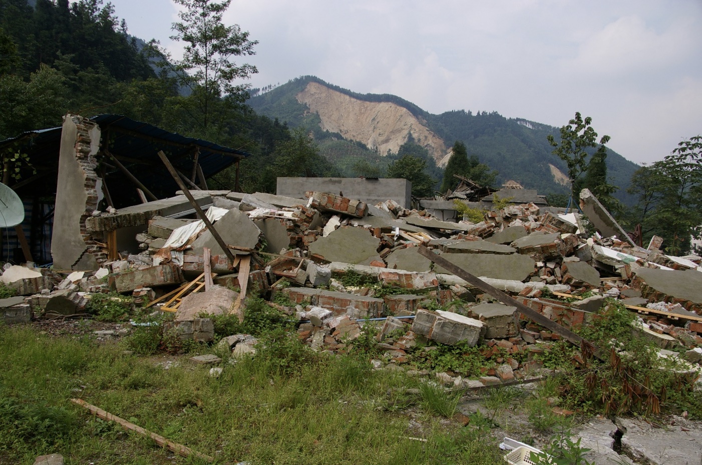 However, many of the buildings are URM-type buildings up to 3 stories in height, with a mixed brick-concrete system (known in the Chinese building code as “restrained brick”) for buildings generally 3 to 7 stories in height. These structures did not perform well. There were some concrete moment-frame buildings that suffered from weak column/strong beam behavior; however, some of these buildings that performed remarkably well, even close to the fault rupture zone.
There were over 7,000 dams in Sichuan Province. There was distress in some of these dams, and 69 were reported to be in danger of failing although ultimately there were no failures. Water lifelines were most severely affected in small rural townships and villages. There was heavy damage to pumping plant buildings which presumably were URMs, however, the pumps remained mostly functional. Power generation plants, particularly hydro and coal-fired plants, were damaged and remained nonfunctional for more than 2 months. Many substations in remote areas were extensively damaged. Transmission and distribution systems were severely impacted by landslides and rockfalls. Telecommunications were also severely impacted due to damage to equipment, damage to the distribution system and loss of power.
 Emergency response to the earthquake was quick and decisive as the central government rapidly deployed 130,000 soldiers of the PLA to provide search, rescue, restore access, and maintain order. Aid from other provinces of China was also mobilized to aid Sichuan Province in its time of trouble and help it recover. Temporary housing was quickly established to provide shelter and comfort to the victims and survivors of the earthquake. There were some survivors, however, that chose not to take residence in the resettlement camps, instead staying in tent camps near their homes to tend to crops or other needs.
There was a lot of not-unexpected damage and harm to structures, lifelines, and lifestyle of victims in this catastrophe given the types of construction and the locations of a large population in this very unforgiving topography and geography. However, the response of the authorities to accelerate rescue and recovery was indeed impressive. This was only possible with a strong central government structure that was willing to commit the resources to this effort and without foreign assistance.
From a personal perspective, participating in this LFE mission was indeed transformational. Reconnaissance allows for individuals with different knowledge and expertise to interact and collaborate, thereby developing a broader and more holistic view of the challenges of dealing with earthquakes and the resulting consequences. LFE has given me and others the opportunities to develop not just professionally, but to establish lifelong and rewarding relationships with who are now my cherished friends. Learning from earthquakes is not just about trying to find the one structural element that failed—it is seeking the overall lessons for us to learn as a citizen of the world. The interdisciplinary interactions from LFE have been beneficial to me as an earthquake professional and hopefully made me a more empathetic and compassionate person. The firsthand experience of these earthquakes gives us the ability to see and feel the pain and loss from these events, and hopefully causes us to learn and strive to make things better for those who occupy this earth and for the generations to come.
Marshall Lew
M.EERI 1978; EERI Honorary Member 2018

Photos, top to bottom: EERI-GEER team with CEA hosts; collapsed highway bridge near Yingxiu; low-rise URM construction in Shenxigou; residential building in Dujiangyan; Marshall Lew in Gaoyuan village.
Resources:
- EERI Learning From Earthquakes Wenchuan Earthquake Reconnaissance Report (PDF)
- Earthquake Engineering Field Investigation Team (EEFIT) Preliminary Field Report
- Khalid Mosalam and Nicholas Sitar: Observations After 5/12/2008 Wenchuan Earthquake Based on Field Reconnaissance from 7/4/2008 to 7/7/2008 (PDF)
- PEER August 18, 2008 Wenchuan Earthquake Seminar: Speaker Presentations
LFE Earthquake Reconnaissance Retrospective #6: June 23, 2020 Oaxaca Earthquake and Virtual Reconnaissance
On June 23, 2020, at 10:29 AM local time, a M7.4 earthquake struck the state of Oaxaca in Mexico, causing moderate damage throughout the state and triggering a 60-centimeter high tsunami along the Oaxaca coastline. The earthquake resulted in ten deaths and damaged thousands of residential buildings. Schools, hospitals and clinics, bridges, and highways also experienced structural damage. At the time, the region was still recovering from previous earthquakes, including the 2017 M8.2 earthquake in the neighboring state of Chiapas. The impact of the 2020 earthquake was also compounded by the COVID-19 pandemic, which strained healthcare systems and presented an additional challenge for post-earthquake reconnaissance efforts. Below, Erica Fischer (M.EERI 2010), EERI Vice President from 2019-2022 and co-founder of the LFE Virtual Earthquake Reconnaissance Team (VERT), reflects on the role of virtual reconnaissance in responding to this and other earthquakes.
Virtual Reconnaissance and Beyond: a personal account by Erica Fischer
VERT began in 2015, when Manny Hakhamaneshi and I both finished our PhDs. We were trying to figure out what the role of younger members could be in LFE could be going forward, having both been involved in co-founding the Younger Members Committee (YMC) just after finishing graduate school. At the 2015 Annual Meeting in Boston, we convened a group of younger members, and one of the things we heard over and over again was that younger members wanted to become more involved in reconnaissance in some way, shape, or form. I had participated in reconnaissance in Haiti in 2010, Napa in 2014, and later went to Italy in 2016, but many graduate students and early career members had not had an opportunity to participate in a field reconnaissance mission.
When the 2015 Nepal earthquake happened shortly after that meeting, there was a whole virtual arm of the EERI response—supporting the teams that went to the field, blogging about a variety of different topics, and bringing together people from all over the world. The majority of them seemed to be younger members, and so Manny and I started thinking—what if we did this for every EERI earthquake response? We realized that we could serve as a virtual arm of LFE, and we saw how beneficial it was to be able to supply reconnaissance teams with a whole packet of information before they even left for the field. We were also seeing just how much information was becoming available through both social media, mainstream media coverage, and through EERI’s vast international network. Virtual reconnaissance was not just as a way to strengthen and support field reconnaissance efforts, but also a way of providing an opportunity for EERI membersto participate in reconnaissance remotely by synthesizing all of this virtual information that was newly available.
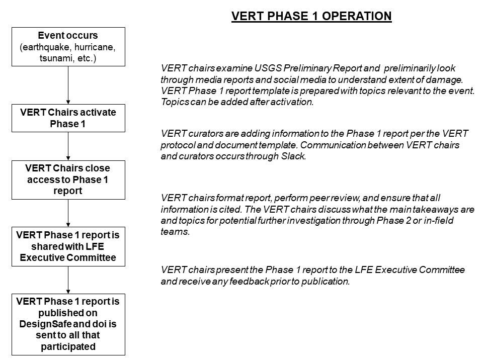 While VERT started off as a mechanism to engage younger members within EERI, today we engage EERI members at all levels of their careers. When VERT activates, we rely on EERI’s international networks to connect with local researchers. They can supply preliminary reports of ground motion data and impacts to guide us. Simultaneously, we begin gathering information on impacts from social media and other sources. Members begin to take leads on different sections of the report (e.g. geotechnical impacts, building damage, transportation impacts), with more experienced members taking the leads of these sections. Those who are participating communicate using tools like Whatsapp or Slack, and we start spatially piecing together where the damage was and try to identify where we are missing information. Our goal is to get a holistic understanding of what happened. We also draw on reports from previous earthquakes and information about building codes to provide context to the damage, or what performed well. In addition, we invite the other LFE subcommittees to participate, such as business resilience, SESI, public health working group, so that our reports can be useful to the EERI community.
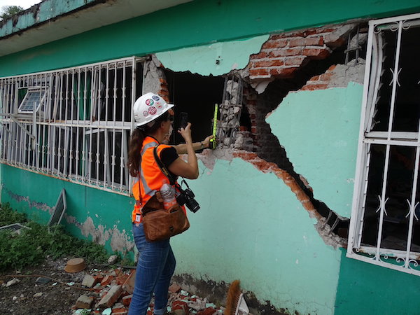 Our reports can be used in a variety of ways. One aim is to inform those doing in-field reconnaissance about what to look for and potential sites or phenomena of interest - our last section of the report always includes recommendations for in-field reconnaissance. Providing this preliminary virtual layer of investigation allows field teams to focus on more in-depth data analysis. Another goal is to provide real-life examples for researchers interested in particular types of structures or failures—combined with ground motion data, these examples can help validate numerical simulations and improve models. All of our reports are published through DesignSafe-CI, therefore they have DOI that researchers can cite.
After Nepal, VERT spearheaded this virtual approach for earthquakes for Ecuador and Taiwan in 2016, both the Chiapas and Puebla Mexico events in 2017, Anchorage in 2018, and Ridgecrest and Albania in 2019. Our first pandemic-era response was the Magna, Utah earthquake, which was the one that set the stage for the Oaxaca earthquake response a few months later. Magna was an important earthquake , as this was a significant event in a part of the U.S. that has well-known seismic risks but hadn’t experienced a substantial earthquake in a long time. This was mid-March 2020, right at the beginning of the pandemic. The hospitals were already burdened with COVID-19. VERT gathered information on hospitals with respect to impacts on capacity and functionality. Information on impacts due to the earthquake, and then impacts related to treatingCOVID-19 patients in addition to those needing care for earthquake-related injuries. This type of focus was new for LFE because it represented two hazards occurring at the same time—such as a health hazard like the pandemic and a natural hazard like earthquakes—and how this complicates emergency management as well as the reconnaissance response.
These questions about interdependencies in critical infrastructure and concurrent hazards continued to inform our approach to other earthquakes that occurred in 2020 and 2021. When the earthquake struck Oaxaca in June, we were interested in looking at how this event compared to the 2017 earthquake affecting the region—three years isn’t a lot of time to recover and develop new approaches to building practices, so we wanted to see what had or hadn’t changed in terms of the kinds of damage that happened and the impact on the recovery process. 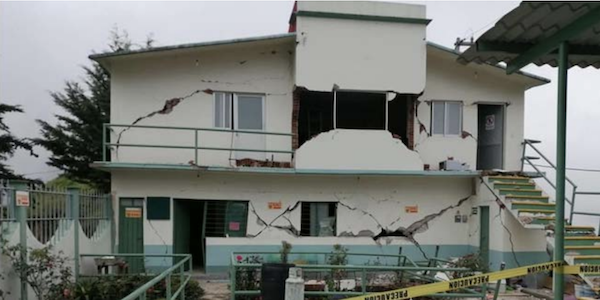 Drawing on the lessons from Magna, we also focused on hospitals and healthcare systems, and because this is an area where the economy is very dependent on tourism, we also looked at business and economic impacts. The pandemic meant the tourism economy was already suffering, and businesses were dealing with COVID-related shutdowns already. So part of the response was to engage the Public Health and Business Resilience working groups in LFE to look at the intersection of COVID-19 policy in the health and business sectors with the effects of the earthquake. For the Oaxaca earthquake in particular, VERT collected data on businesses for almost a year after the earthquake occurred, tracking business recovery within the region, all remotely.
Just as post-earthquake reconnaissance has expanded from taking photos of building damage to using new technologies like drones and LiDAR and satellite imagery and real-time ground motion data, we are also finding new opportunities to engage across disciplines and hazards. For example, I now do a lot of wildfire reconnaissance, which would not be possible without the knowledge I gained through this work, and I see people taking the same lessons and skill sets developed through EERI’s earthquake reconnaissance and branching out into work on other hazards such as hurricanes, building deterioration, and more. Virtual reconnaissance during the pandemic also provided insight into how we can use these approaches for situations where natural and other hazards are occurring alongside social and political conflict. A pandemic is not the only situation that might limit our abilities to do in-field reconnaissance—it can also be impossible because of social and political unrest, as in Haiti in 2021. It might not be safe to send a team into the field, but there are still important lessons to be learned from the earthquake.
Virtual reconnaissance also helps researchers and practitioners develop skills and relationships. We have very senior, experienced engineers participating in the development of our VERT reports, working side by side with early career engineers and students— it’s a chance for younger engineers to connect with others in the profession and gain an understanding of what happens in an earthquake. We also work in close collaboration with organizations such as the Structural Extreme Event Reconnaissance (StEER) Network, Geotechnical Extreme Event Reconnaissance (GEER) Team, USGS, other partners in the reconnaissance community. This complimentary approach allows us to avoid duplicating work and make the best use of our volunteers’ time. Sometimes we activate for earthquakes that StEER doesn’t respond to, like the Michoacan and Taiwan earthquakes in 2022, and vice versa. But often, as in the response to the 2023 earthquake sequence in Turkey, we collaborate, using a shared communications platform and producing a joint report. Our goal is to get this information out to EERI and the broader reconnaissance community as fast as possible in the most comprehensive way.
Henry Degenkolb used to say that earthquake engineers can’t really do the job until they see the aftermath of an earthquake firsthand. Witnessing the impacts of earthquakes on our infrastructure provides an immersive experience to understand that a building is not just a series of beams, columns, and slabs. This is someone’s home or school or the hospital where their family member is being cared for. There’s a human side to earthquake engineering that is very difficult to teach engineers, and virtual reconnaissance provides at least that first step of access to that. But while virtual reconnaissance is useful, especially when it’s not possible to go to the field in person, it can’t be a replacement for field reconnaissance. There is no substitute for the relationships you build in the field, particularly the cross-cultural dimensions when working side-by-side with engineers from another country, and it is critical for us to develop those connections. I am still in touch with many Haitian engineers I met during my first reconnaissance trip in 2010, and I also still work with many of the US colleagues who were involved—same for the people I met in Italy in 2016 and Mexico in 2017. Those relationships are important because they allow us, as engineers, to understand both the human side of these disasters and the cultural context in which they occur.
Erica Fischer
M.EERI 2010, Co-Chair, Virtual Earthquake Reconnaissance Team
Assistant Professor, School of Civil and Construction Engineering, Oregon State University

Images, top to bottom: VERT operational flowchart; Erica Fischer conducting field reconnaissance in Mexico in 2017; damage to a medical facility in Oaxaca in 2020; Fischer on LFE reconnaissance mission in Italy.
More information
- EERI Virtual Earthquake Reconnaissance Team (VERT): Phase 1 Response to M7.4 Crucecita, Oaxaca, Mexico Earthquake, June 23, 2020
- StEER Crucecitas, Mexico Mw 7.4 Earthquake: Preliminary Virtual Reconnaissance Report (PVRR) Crucecitas, Mexico Mw 7.4 Earthquake: Preliminary Virtual Reconnaissance Report (PVRR)
- February 6, 2023, Kahramanmaras, Türkiye, Mw 7.8 Earthquake Preliminary Virtual Reconnaissance Report February 6, 2023, Kahramanmaras, Türkiye, Mw 7.8 Earthquake Preliminary Virtual Reconnaissance Report (joint product of StEER and EERI LFE/VERT)
- VERT presentations and other resources on 2017 Chiapas Earthquake VERT presentations and other resources on 2017 Chiapas Earthquake
LFE Reconnaissance Retrospective #7: Kocaeli 1999
On August 17, 1999 at 3:01 AM local time, a M7.4 earthquake struck Turkey’s Kocaeli province, causing intense ground shaking across a wide region around the northeastern coasts of the Sea of Marmara. The worst of the devastation occured in the cities of İzmit, Gölcük, Yalova, and Adapazarı, but İstanbul—Turkey’s largest city and economic and cultural capital, some 80 kilometers from the epicenter—also experienced significant impacts. Over 17,000 people were killed, tens of thousands more were injured, and at least 250,000 were left homeless. The earthquake caused a tsunami of 1.5-2.6 meters in the Gulf of İzmit, which was responsible for at least 150 of the deaths. The earthquake also caused billions of dollars of economic damage due to the loss of housing and the impacts to lifelines and infrastructure (including an oil refinery fire) in a highly industrialized and heavily populated area of Turkey. An EERI Learning From Earthquakes reconnaissance team arrived in the region on August 20, less than 72 hours after the earthquake. Below, EERI Honorary Member and former editor of Earthquake Spectra Hakkı Polat Gülkan (M.EERI 1993), then a professor at Middle Eastern Technical University in Ankara, recalls the experience.
Kocaeli 1999: a personal account by H. Polat Gülkan
 I knew of that M7.4 earthquake first through our neighbors in Ankara, some three hundred kilometers away from the epicentral area, who had been awakened by the sway of the building where we lived. Had I felt the earthquake? No I hadn’t. Then the phone rang, with someone from the BBC asking for news details about which I knew nothing. The news streaming on the local media was very depressing.I knew of that M7.4 earthquake first through our neighbors in Ankara, some three hundred kilometers away from the epicentral area, who had been awakened by the sway of the building where we lived. Had I felt the earthquake? No I hadn’t. Then the phone rang, with someone from the BBC asking for news details about which I knew nothing. The news streaming on the local media was very depressing.
We arrived in the area by car one day later. The level of the physical destruction that our teams recorded along the 150-km long fault rupture area over the next ten days was reminiscent of historic earthquakes in Turkey that I had read about, but seeing it first hand was a new experience altogether.
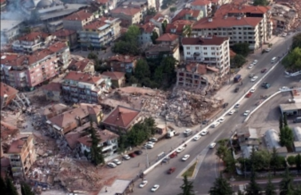
The human dimension of the disaster outweighed the heaps of rubble that urban streets had now become. People who until a few days ago had been living comfortable lives in their six-story apartment flats were now sleeping out in tents under miserable conditions, and the smell of disaster hung over the major settlements such as Gölcük, Yalova, Izmit and Adapazarı.
On one of these random trips to various settlements my team met with the EERI-LFE one to figure out where to snap pictures. I recall seeing Mark Aschheim and Ken Elwood who was then a graduate student at Berkeley. We were all standing in muddy boots under an unexpected drizzle on one side of a park close to the Governor’s Office in Adapazarı. The buildings that surrounded us were all tilted one way or the other like from some post-apocalyptic film set. Thinking we were some sort of relevant delegation people streamed past the group to report their urgent needs or grievances, wondering if we could be of help. The rain forced us to devise makeshift protection from the falling drops. Elwood’s solution turned out to be a plastic sheet, like the cover they put around garments when one picks them up from the dry cleaners. He punched a hole on the upper end to allow his head to go through, but of course his arms were now locked, unable to move. After some reflection he said: “I’m not going to complain because that would be an insult to all of these people, all victims of this disaster, around us.” That needed no comment or approval.

H. Polat Gülkan
M.EERI 1993, EERI Honorary Member
Professor of Earthquake Structural Engineering, Başkent University, Ankara
More information
- The Izmit (Kocaeli), Turkey Earthquake of August 17, 1999 (EERI Special Earthquake Report, October 1999)
- Kocaeli, Turkey Earthquake (Earthquake Spectra Volume 16, Special Issue 1, December 2000)
- Structural Engineering Reconnaissance of the August 17, 1999 Kocaeli (Izmit) Earthquake (Pacific Earthquake Engineering Center, December 2000)
LFE Earthquake Reconnaissance Retrospective #9: Loma Prieta, October 17, 1989
On October 17, 1989 a M6.9 earthquake struck on a segment of the San Andreas Fault north of Santa Cruz, California, at 5:04 PM local time. The earthquake caused 63 deaths and 3,757 injuries, landslides and liquefaction, and damage to buildings and infrastructure throughout the San Francisco Bay Area. Transportation infrastructure was particularly affected—a section of the upper deck of the Bay Bridge collapsed, as did a portion of the double-deck Cypress Street Viaduct of Interstate 880 in West Oakland, causing the majority of the fatalities. Below, Eduardo Miranda (M.EERI 1987), co-chair of the Learning From Earthquakes program, recalls the reconnaissance efforts at the Cypress Street Viaduct.
Loma Prieta 1989: a personal account by Eduardo Miranda
 My deep dive into earthquake engineering started on September 19th, 1985 in Mexico, the day when an M 8.0 earthquake hit the city where I was born and grew up very hard. I was 22 at the time and I was finishing my undergrad degree at UNAM. I had almost completed all my courses, and I was a research assistant at the Institute of Engineering. The earthquake produced ground motions that exceeded the design spectrum by more than four times. I quickly learned what that meant. Hundreds of engineered buildings collapsed, many designed with standards similar to those of the UBC, AISC and ACI. It was my first time being in front of buildings collapsed by earthquakes. As a result of what I witnessed, is that I decided I would dedicate my life to learn and improve earthquake resistant design.
When the Loma Prieta earthquake occurred, I was a PhD student at Berkeley working with Professor Bertero. Power was lost immediately. The first thing that came to mind that ATMs would not be working and that I need to borrow cash from my neighbors to but all the film I could get hold off. I was a graduate student without too much money, but I knew taking many photos was going to be important.

We met Professor Bertero at 6am at RFS the following morning and we started our reconnaissance. The first day I went with Andrew Whittaker to Santa Cruz. Soon many of us ended up for several days in the Cypress Street Viaduct. Luck was in our favor—the only one of the graduate students who had a car wa s Doug Nims, but his wife who was a nurse needed it, so we all went to the viaduct by BART. We went out on the West Oakland station and we walked toward the collapse from the south.
Over the years I have done reconnaissance after many earthquakes in many countries and I have stood in front of many collapses, including several very large buildings such as the Pino Suarez complex in Mexico City in 1985 or the Alto Rio in Concepcion in 2010. But nothing has been as shocking as the 1.25 kilometer-long collapse of the upper deck of the Cypress Street Viaduct onto the lower deck. As we were walking, we started to understand the long and complex viaduct bent by bent. The damaged progressed, with each bent having more damaged than the previous. The collapse was being showed to us frame-by-frame in a sort of slow motion. By the time we arrived to the first collapsed bent, we had a very good idea on how it had started and how it had progressed. Search and rescue was still ongoing at the time. We were doing our reconnaissance next to first responders and volunteers from the Port of Oakland.
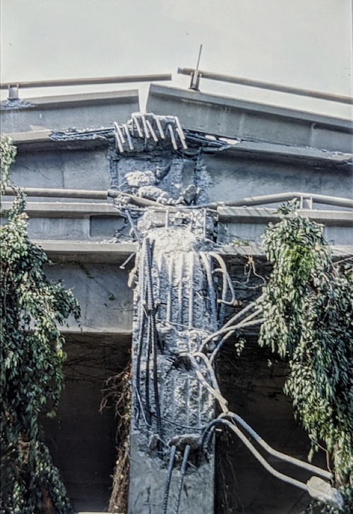 We worked there several days, taking hundreds of photos and notes of all details. Prior to that collapse I had only seen #18 bars in the construction of a spillway in a large dam I visited under construction while I was a student in Mexico. This time I was seeing them bent like shoelaces. Very large columns and bents had been shattered by the earthquake. One needed a human scale to appreciate the size of this collapse.
Of the many portions of that collapse, the one that I will never forget is one of the columns in bent 108. The columns were 4x6 ft reinforced with 44 #18 bars. The earthquake had produced the largest shear failure I have ever seen. A quick back-of-the-envelope calculation revealed that just to fail the 6 ksi concrete a force of more than 5,000 kips, more than half a million pounds had acted on that column.
We convinced Jim Roberts to stop the demolition of the viaduct for two hours. He told us we could work from 6:00 to 8:00 PM. We rented a U-haul truck and loaded all the equipment and we got there exactly at 6:00pm.
We used a telescopic basket to get to the deck levels. We were able to measure ambient vibrations in three different configurations. It was those measurements on bents 45, 46 and 47 that then helped convince Caltrans not to demolish those bents to try different retrofits.
I still keep some photos of the sketches we did on the white board of the computer room in RFS. That careful reconnaissance allowed a group of young graduate students to identify not only the typical modes of failure, but also explain why the skewed bents 96 and 97 survived or why the collapse very likely was initiated at bents 73 and 74 which had approximately half the lateral strength of the typical bent.
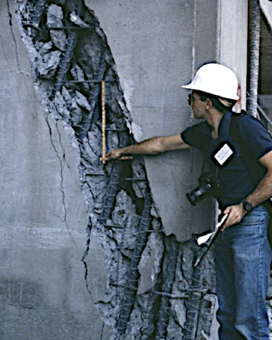
I will remember that reconnaissance for the rest of my life. It led to my first EERC report, published 30 days after the earthquake, which was subsequently copied essentially word by word and included all of our photos in the report of the Board of Inquiry of the earthquake headed by Professor Housner to the Governor of California. We all received a special citation from Governor Dukemejian for the work we did as students. Later, it also led to my first paper in BSSA—and taught me the importance of Learning From Earthquakes.

Eduardo Miranda
M.EERI 1987, Co-Chair Learning From Earthquakes
Professor of Civil and Environmental Engineering, Stanford University
Images, top to bottom: Supplies and EERI membership card; collapsed section of Cypress Street Viaduct; column and rebar on Cypress Street Viaduct; Eduardo Miranda (Ian Aiken), Eduardo Miranda.